
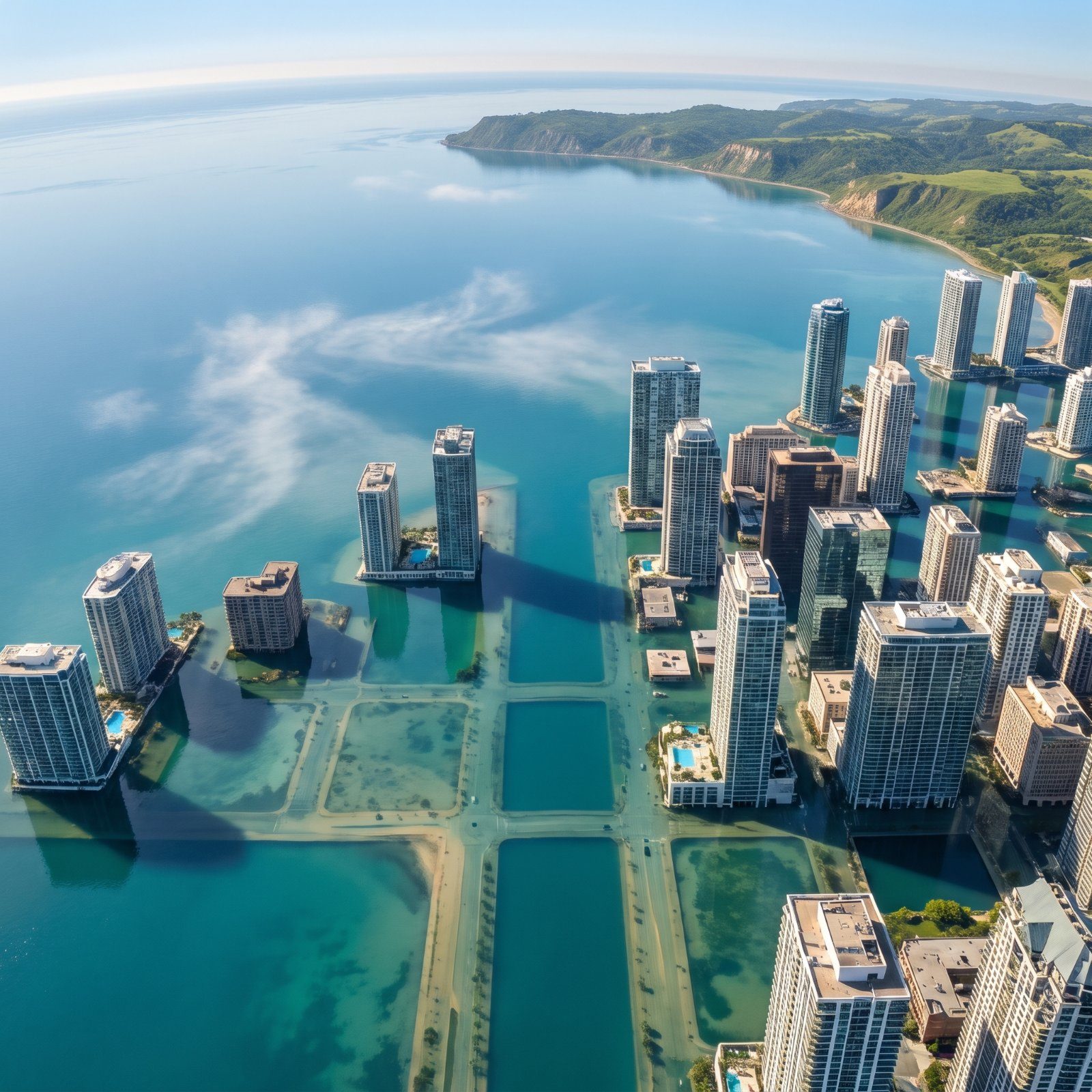
Two hundred feet is not a prediction. Melt every glacier and ice sheet on Earth, pour the whole lot into the ocean, and that’s roughly what you get. It would take centuries. But the geography it reveals is real right now, written into the elevation data under our feet. Some skylines barely notice. Others vanish to the rooftops, and the gap between the two often comes down to a few dozen feet of dirt nobody ever thinks about. These visual tours drop the new coastline exactly where the topography says it belongs — and the results are stranger than any disaster movie, because they’re quietly, believably true.
49. Miami, The Ocean Swallows South Florida Down to the Rooftops
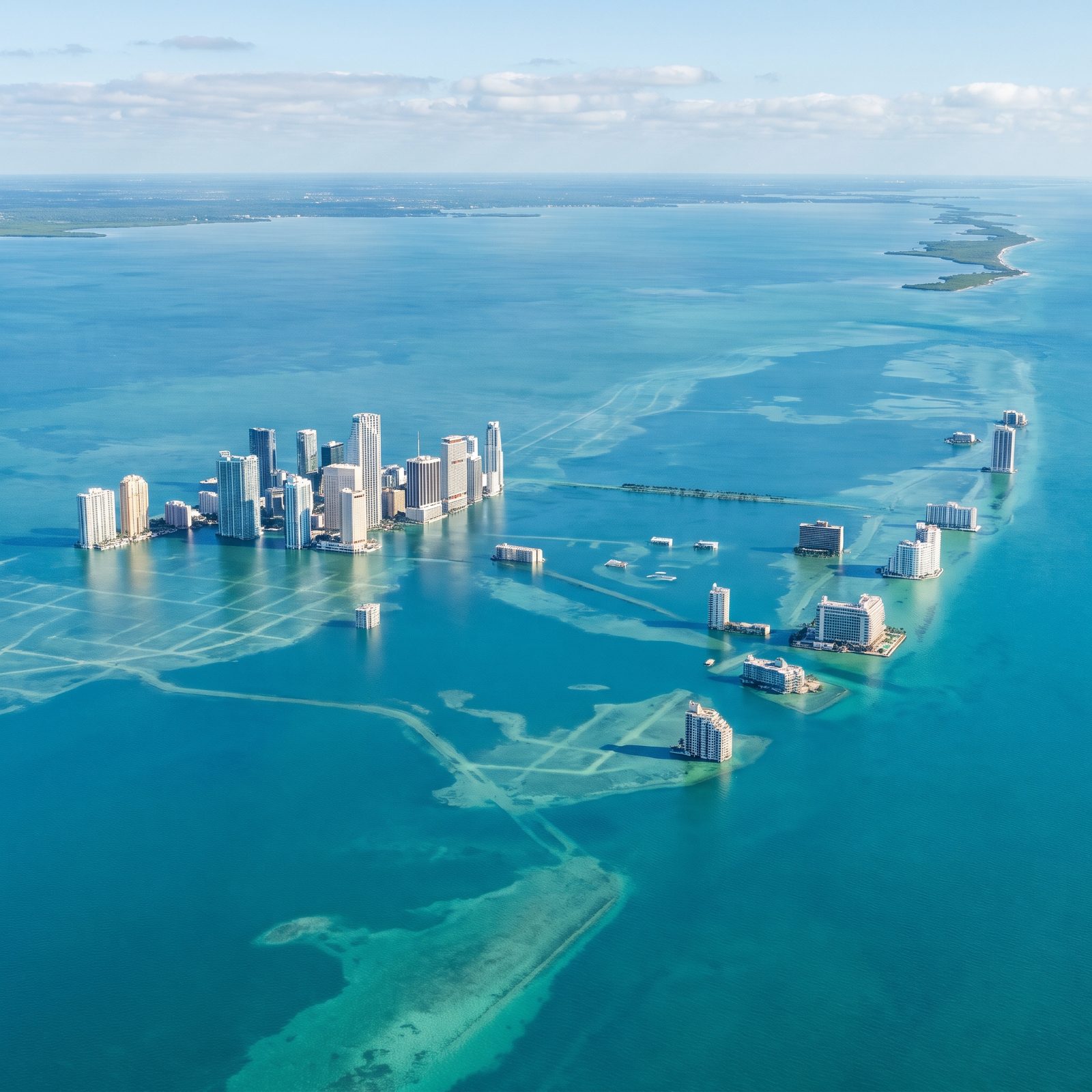
Miami’s highest natural ground sits around 25 feet above sea level, and most of the city hovers at six to ten. Do the math. A 200-foot rise doesn’t just flood Miami — it drowns its streets, leaving the downtown towers as islands and Miami Beach gone except for a handful of rooftops.
The cruel part is the limestone. South Florida sits on porous rock that water moves through sideways, which is why seawalls do so little here. You can’t hold back a tide that comes up from underneath.
48. New Orleans, The Mississippi Delta Vanishes Into the Gulf
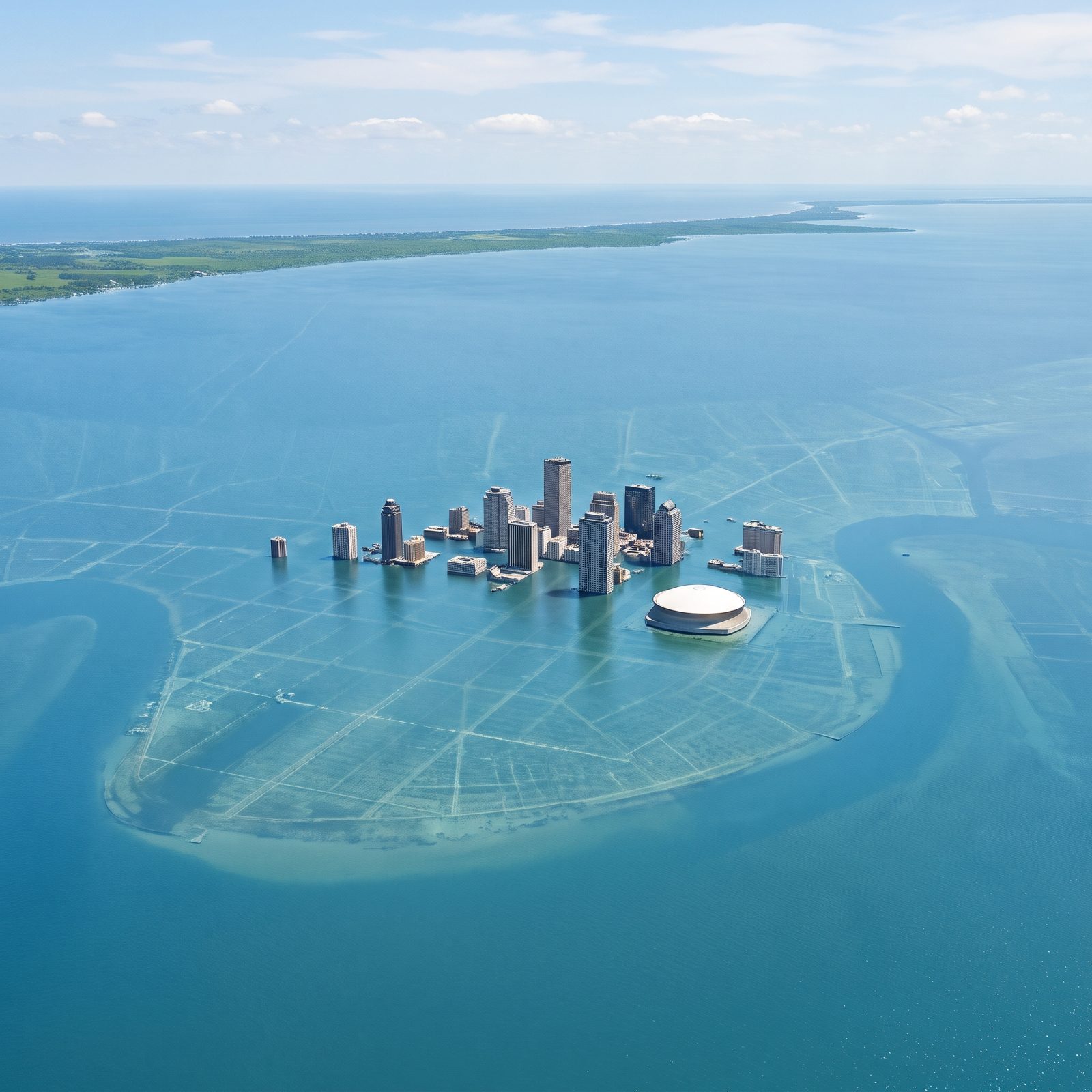
New Orleans barely needs a big rise. Half the city already sits below current sea level, kept dry by levees and pumps grinding away around the clock, and a modest rise of a few feet finishes the job.
What makes the delta vanish while the green, firmer shoreline on the horizon stays dry is that the delta was never solid ground to begin with — the whole thing is river silt, loosely stacked and slowly sinking under its own weight. Take away the river’s yearly deposits, add water, and the land doesn’t just flood. It unspools back into the Gulf it came from, and the Superdome becomes a dome in a very literal sense.
47. San Francisco, The Bay Floods Inland and the Peninsula Shrinks to Hilltops
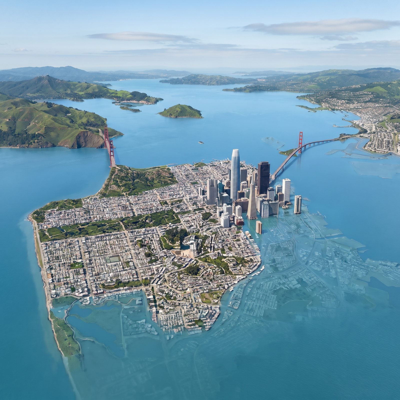
San Francisco survives better than most, and you can thank the hills. Twin Peaks, Nob Hill, Russian Hill, the whole lumpy spine of the peninsula keeps its head above water, but the flat neighborhoods around them are not so lucky.
SoMa, the Embarcadero, the eastern and southern districts — the neighborhoods built on filled-in bay mud are already underwater, their streets and buildings visible beneath the surface. That fill was never land in the first place, just rubble and sand dumped into the shallows over a century of city-building, and the bay has taken its old floor back.
The Golden Gate Bridge keeps its towers, its roadway still well clear of the water. The real change is right there in frame, where the bay drowns the whole southern half of the city and the peninsula beyond.
46. Los Angeles, The Pacific Reclaims the Flat Coastal Basin
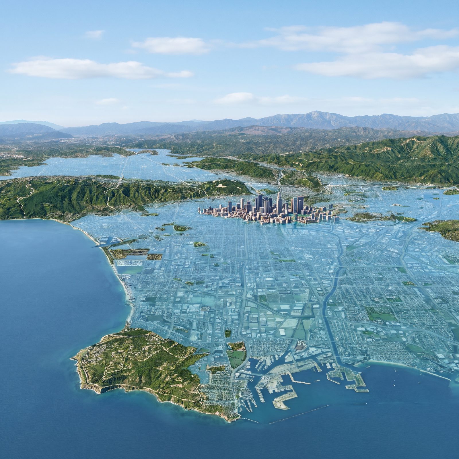
Los Angeles gets saved by its geology, mostly. The Santa Monica Bay beaches, the marina and the port’s piers and breakwaters go under first, and behind them the flat basin follows, and only the mountains themselves, the Santa Monicas, the San Gabriels, the Hollywood Hills, stand clear as the water laps right up to the foothills.
Downtown sits high enough on the basin slope to keep its towers partly dry. The water pushes miles inland across the pancake-flat flood plain, following the same path rivers and runoff have always taken. Topography decides everything here. Low ground goes under; only the slopes and high ground stay dry.
45. Seattle, Puget Sound Climbs Up and Drowns the Waterfront Districts
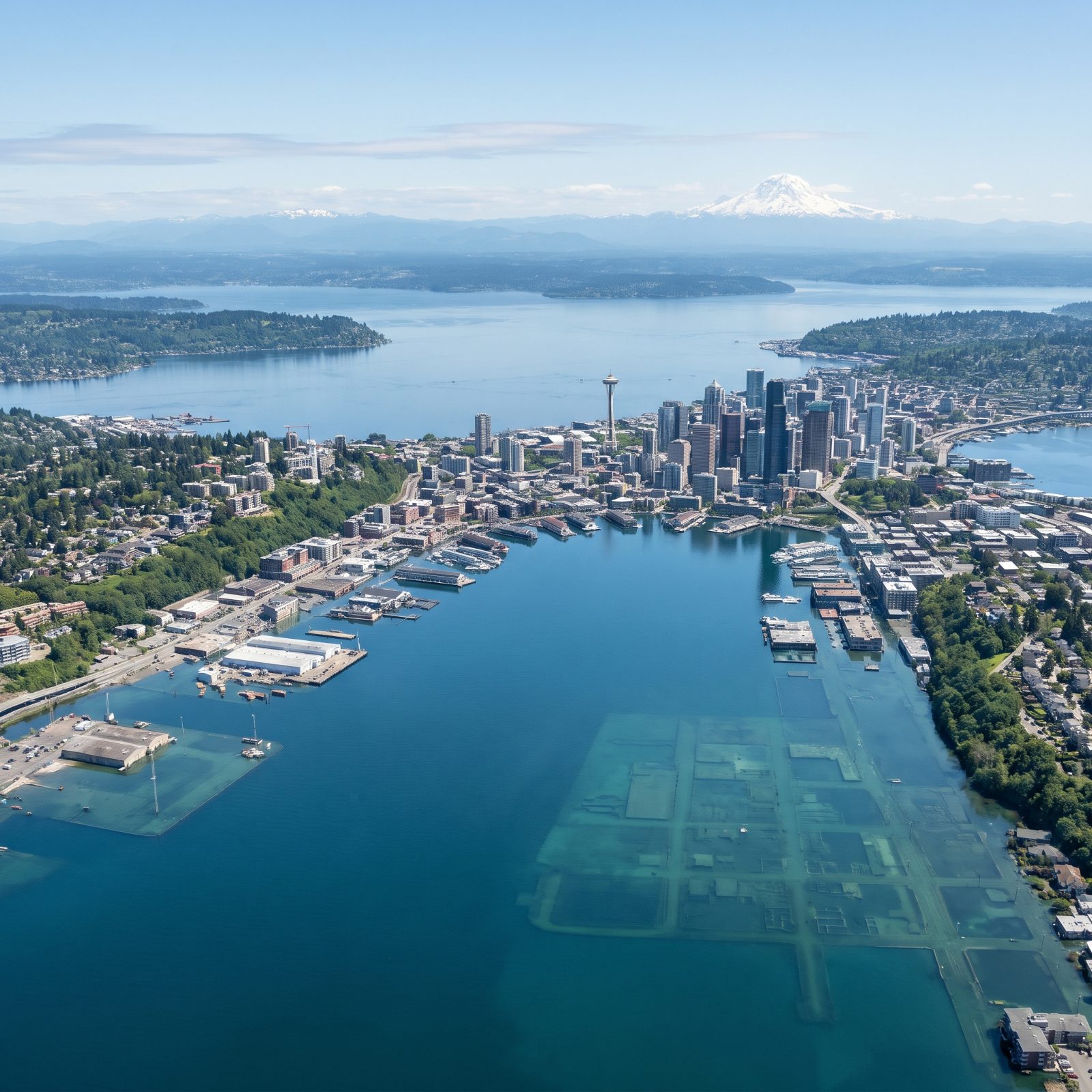
Seattle is a tale of two elevations. The hills carry the city. The industrial flats pay the price.
Downtown climbs steeply from the shore, so the Space Needle and the tower cluster stay well clear of the new water. The central waterfront’s piers and ferry docks go under, and so does the flat ground to the south: the port terminals, SoDo, and that old tide-flat industrial land that was literally hosed into existence by sluicing hills apart in the early 1900s. Reclaimed ground, returning to tideflat.
And here’s the odd twist worth picturing. Even with the sound pushing inland, Seattle stays one continuous landmass, its streets and lots now ghostly outlines beneath shallow green water south of downtown.
44. Honolulu, Waikiki and the Coastal Core Slide Beneath the Pacific
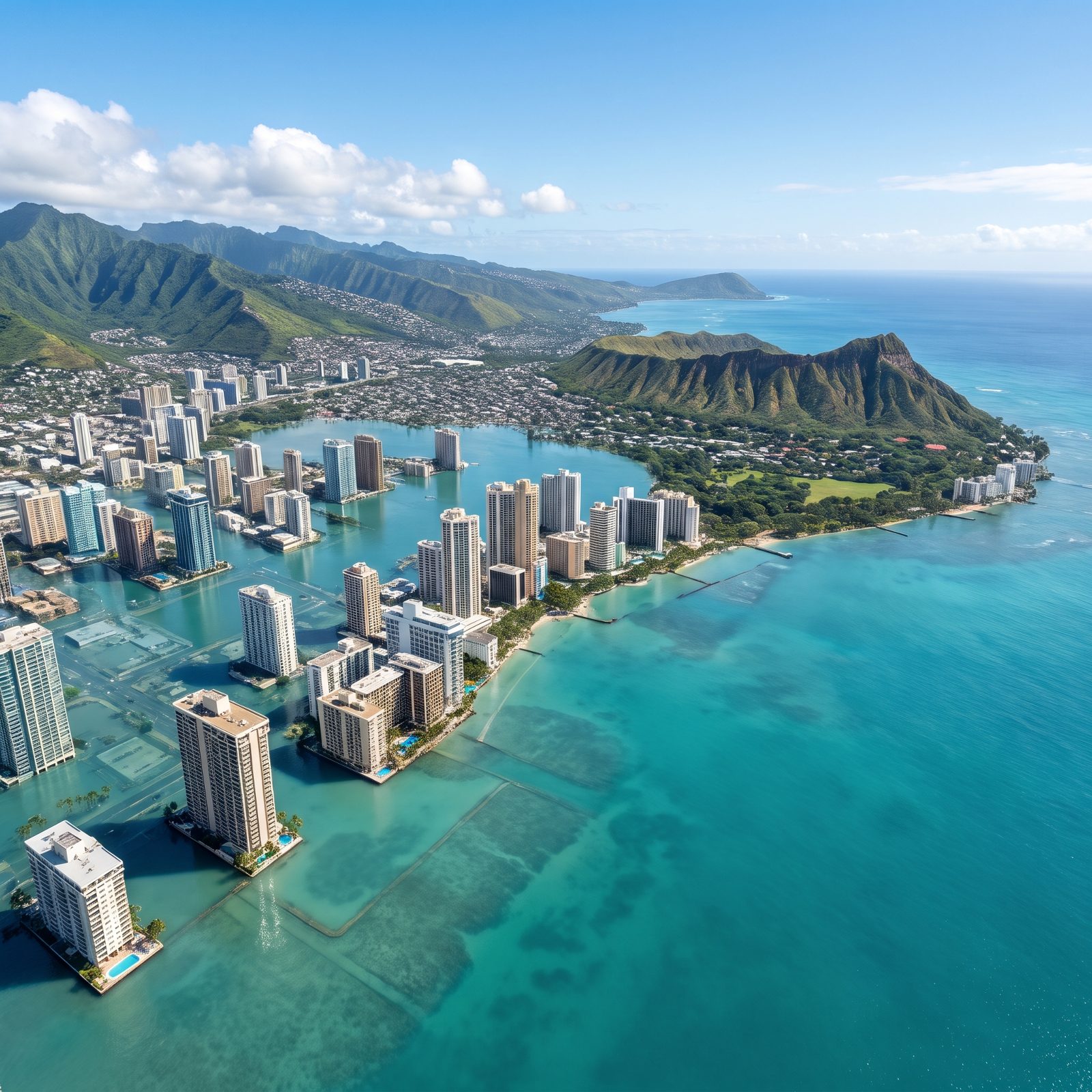
Waikiki is built on an old swamp. Drained, filled and paved in the early 20th century to make room for hotels, the district sits just a few feet above the tideline, which makes the shoreline and the low ground behind it among the first things to go: the sandy beach disappears, and the beachfront hotel towers end up standing directly in open ocean above drowned seawalls and street grids.
Diamond Head rides it out. The crater is a volcanic tuff cone hundreds of feet high, so it remains a dramatic headland, keeping watch over the flooded district inland. The Koolau range behind the city stays lush and dry. What vanishes is the flat land in between, beachfront included — the exact ribbon of land that made Honolulu a resort in the first place.
43. Vancouver, The Fraser River Delta Becomes Open Sea
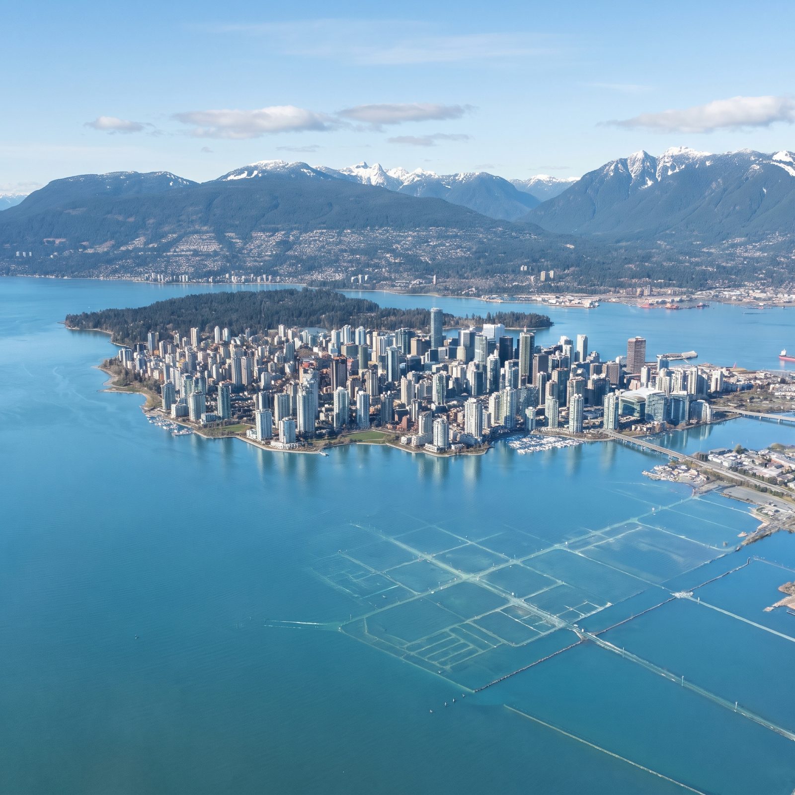
Vancouver’s downtown sits on a peninsula with some elevation, so its towers keep their upper floors above water, though the beaches and marinas go under. The real loss is to the south.
Richmond, the airport, almost the entire Fraser delta — all of it flat, river-built land barely above today’s sea level. Much of Richmond already sits at or below the high-tide mark, held dry by dikes. Breach those dikes and that delta becomes open ocean. The North Shore mountains stay snow-dusted and green, so the picture resolves into a cluster of towers and forested slopes ringing a sea far larger than anyone alive has ever seen there.
42. Havana, The Florida Straits Overrun the Malecón
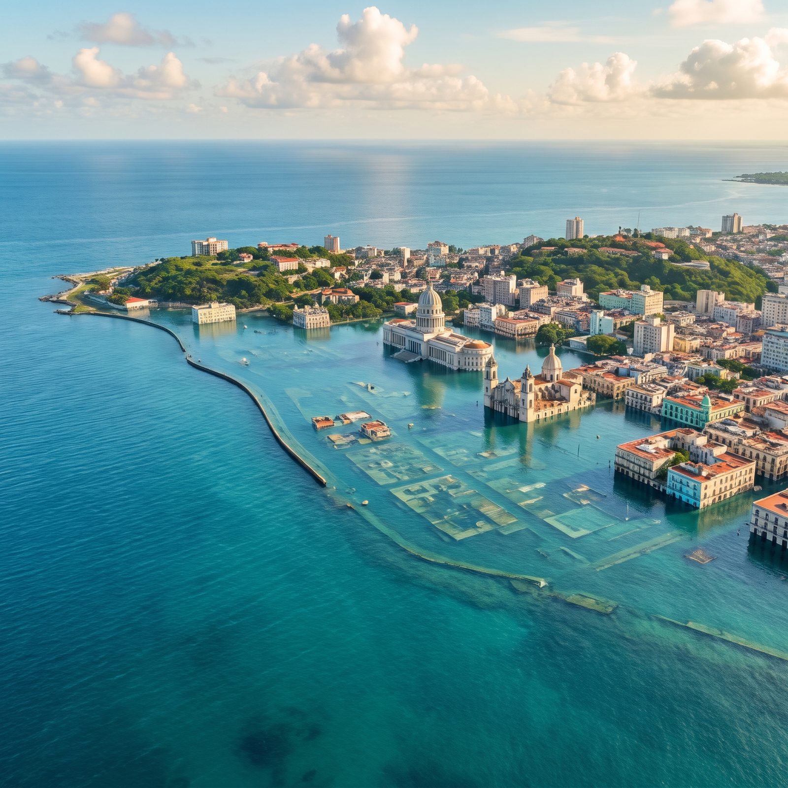
The Malecón, that five-mile seawall where all of Havana gathers at sunset, is the first casualty. It already takes a beating from storm surge today. Under this much rise, only its first stretch still stands clear of the water before breaking off abruptly — the rest of its curve is a faint ghost beneath the surface, and the Florida Straits pour straight over it into a drowned lagoon.
Old Havana, the low colonial grid near the water, floods to the second-story balconies. But the city has relief going for it. Havana rises as you move inland, so church towers and higher neighborhoods stand clear, turning the historic core into a drowned stone lattice with the hills watching from behind.
41. Nassau, Most of New Providence Island Simply Isn’t There
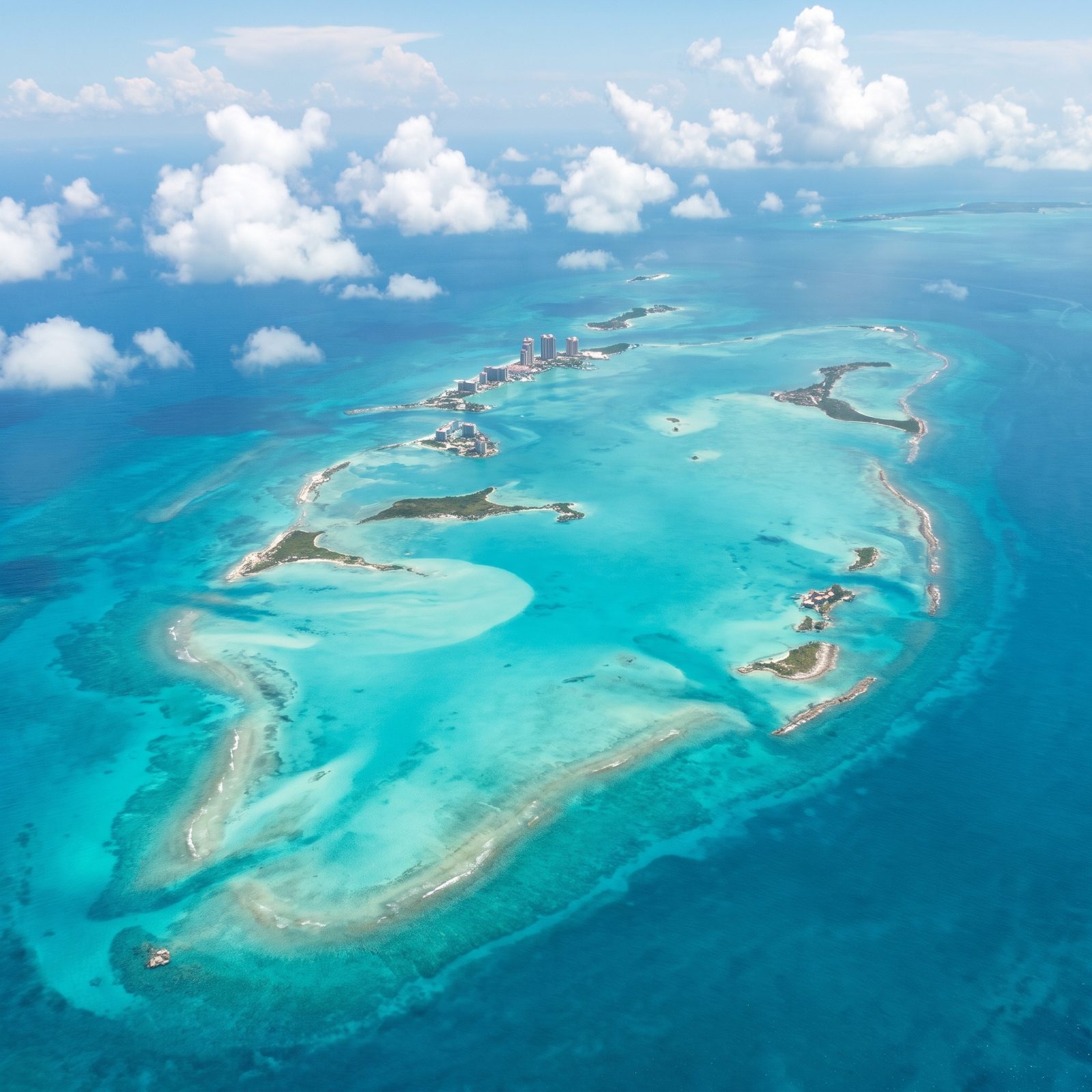
This is where the exercise stops being a city story and becomes a disappearing act. New Providence Island, home to Nassau and most of the Bahamian population, tops out at barely over 100 feet. A 200-foot rise doesn’t flood the island. It submerges nearly all of it.
What’s left looks like an atoll: a ring of reef and low sandy islets circling a turquoise lagoon over the drowned limestone. A few high-rise resort towers still stand on small dry islands with beaches, greenery and marinas, but the streets that once connected them are gone. The low coral platform that built the Bahamas has no mountains to retreat to. When the sea comes up, there’s nowhere to go but under.
40. Panama City, The Pacific Drowns the Canal-Side Lowlands
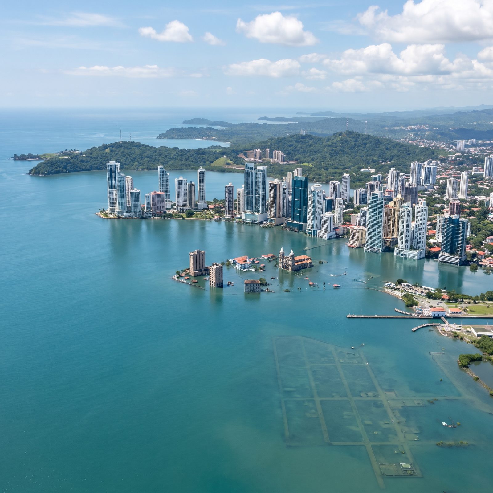
Panama City is a contradiction under 200 feet. The glittering bank towers along the Pacific coast sit on ground with just enough elevation to keep their heads up, lower floors flooded but the skyline intact.
The canal is the fascinating part. The whole system exists because of a roughly 85-foot difference between the oceans and the inland lakes, managed by locks. Yet here the Pacific entrance gives way: the locks, lock walls and port basins lie drowned beneath the bay, their rectangular grid of walls and channels visible only as ghostly outlines under the water, the carefully engineered water staircase erased, and the shortcut between two oceans simply open sea. The low old city floods. The forested hills inland become the new coast.
39. Cartagena, The Walled City Becomes an Island
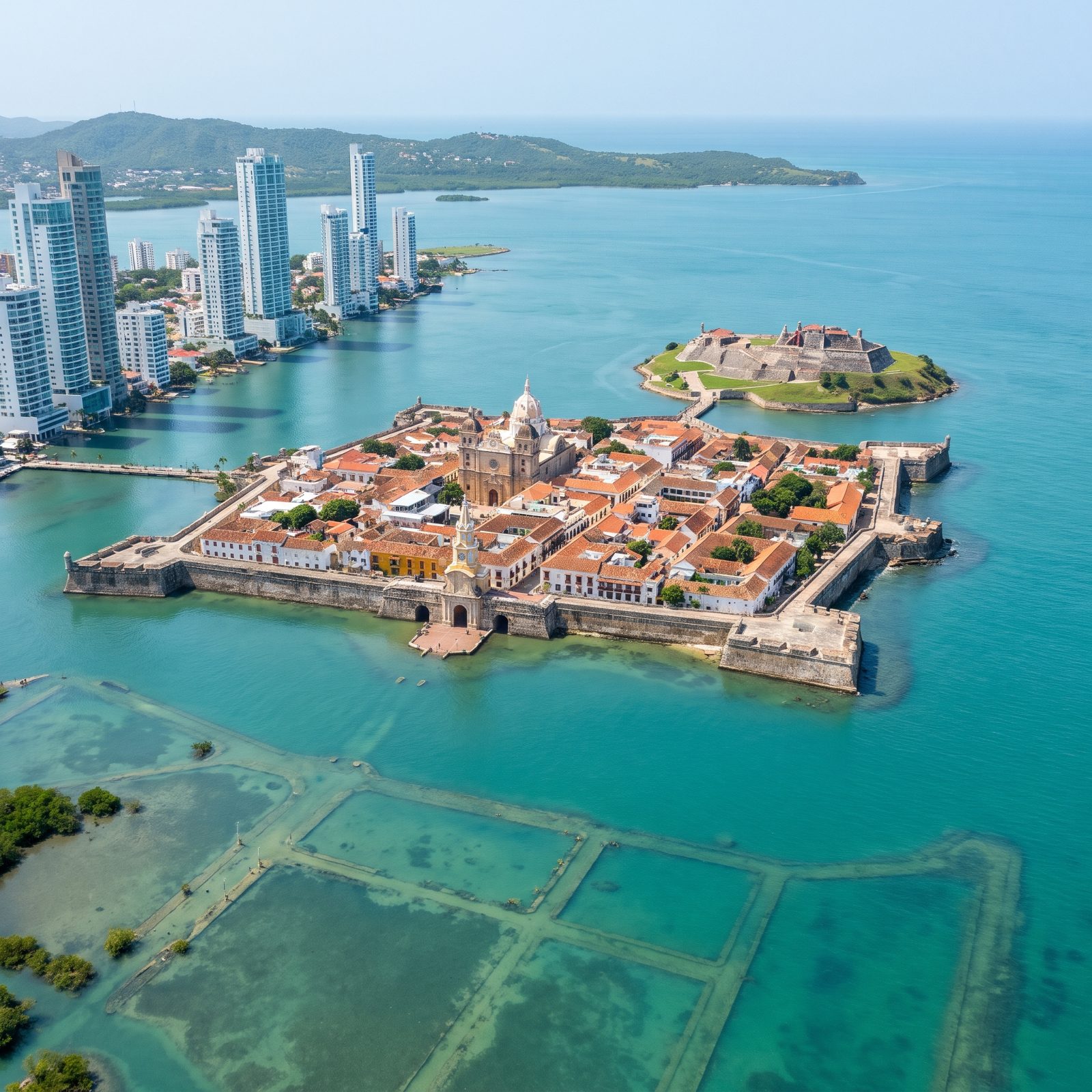
Cartagena already sits low, and that’s the whole problem. The Spanish built the walled city on a flat spit of reclaimed ground, hemmed by mangroves and shallow bays — exactly the terrain that disappears first.
With this much sea-level rise, the stone ramparts that once held off pirates would hold off nothing. The Old Town survives as a stubborn little island, ochre walls rising straight out of the Caribbean, while Bocagrande’s glass towers rise straight out of the water across the bay. Offshore, a stone fortress sits on its own broad, grassy island, well clear of the water and tied to the city by a short bridge.
38. Rio de Janeiro, Guanabara Bay Swallows the Lowlands Between the Mountains
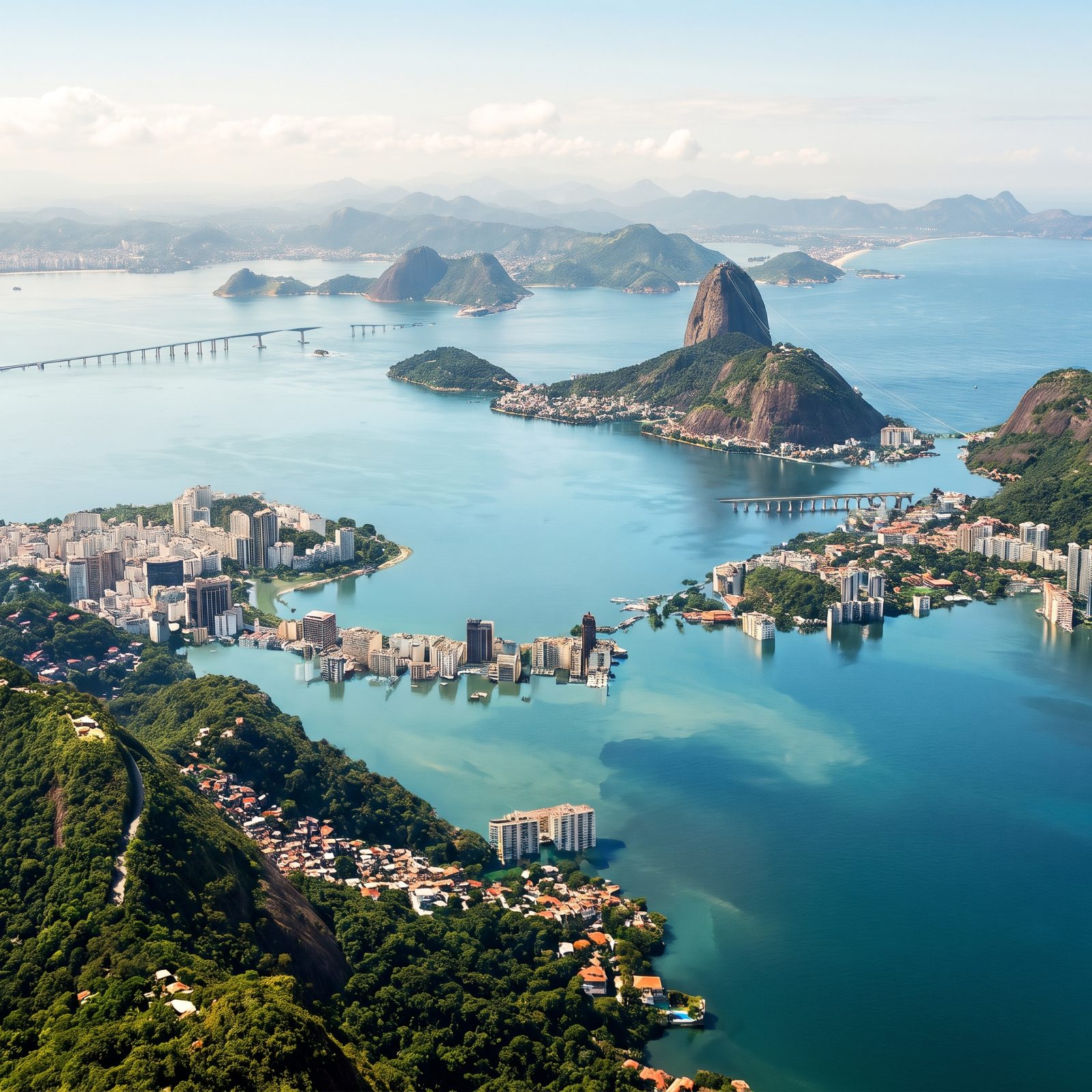
Rio’s drama was always the collision of mountain and sea. Raise the water 200 feet and the mountains win.
Sugarloaf and Corcovado barely notice — they’re granite monoliths that shrugged off millions of years already, and Christ the Redeemer simply keeps watch over an archipelago. But a calm new arm of Guanabara Bay pushes into the flat ground between the peaks: piers, docks and low blocks along the shore slip under the shallows, and whole rows of waterfront high-rises now stand in open water, their lower floors submerged. A sandy beach still catches the surf below the hills. What’s left is a city split between drowned towers and dry hillside neighborhoods ringing a widened bay among half-drowned mountains, which, geologically, is exactly what it would be.
37. Buenos Aires, The Río de la Plata Pushes Deep Into the Pampas
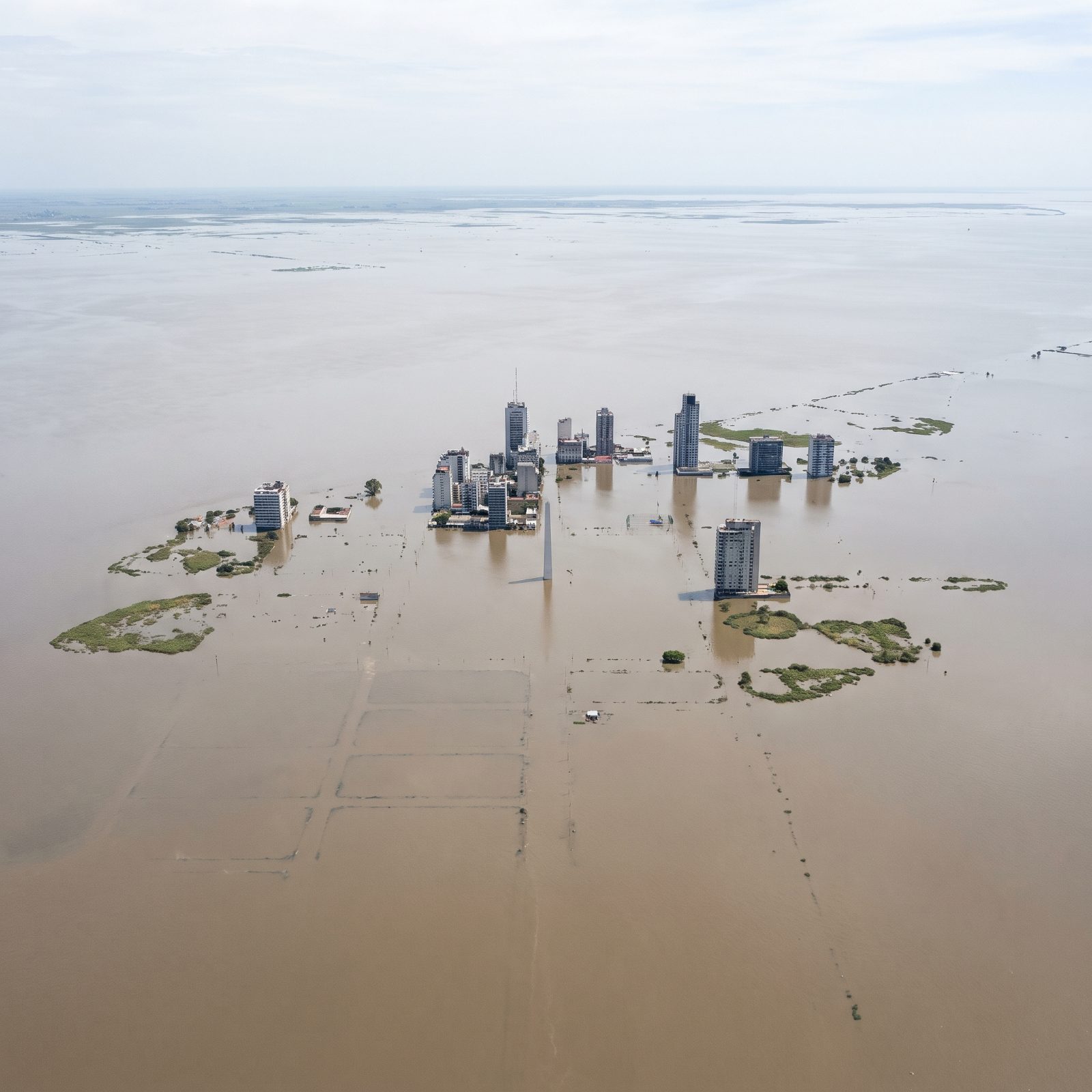
Flat is beautiful until the water comes.
Buenos Aires has almost no elevation to fall back on. The Pampas roll out from the Río de la Plata in a near-perfect plane, so even a rise of a few dozen feet doesn’t nibble at the coast — it drowns the metropolitan area wholesale and keeps marching inland for miles. The Obelisco would stand in open water, most of its shaft still clear of the flood. Downtown becomes a scattering of towers rising from a brown sea.
Cities on flat deltas have the least to argue with.
36. Lima, The Pacific Climbs the Desert Cliffs and Floods the River Valleys
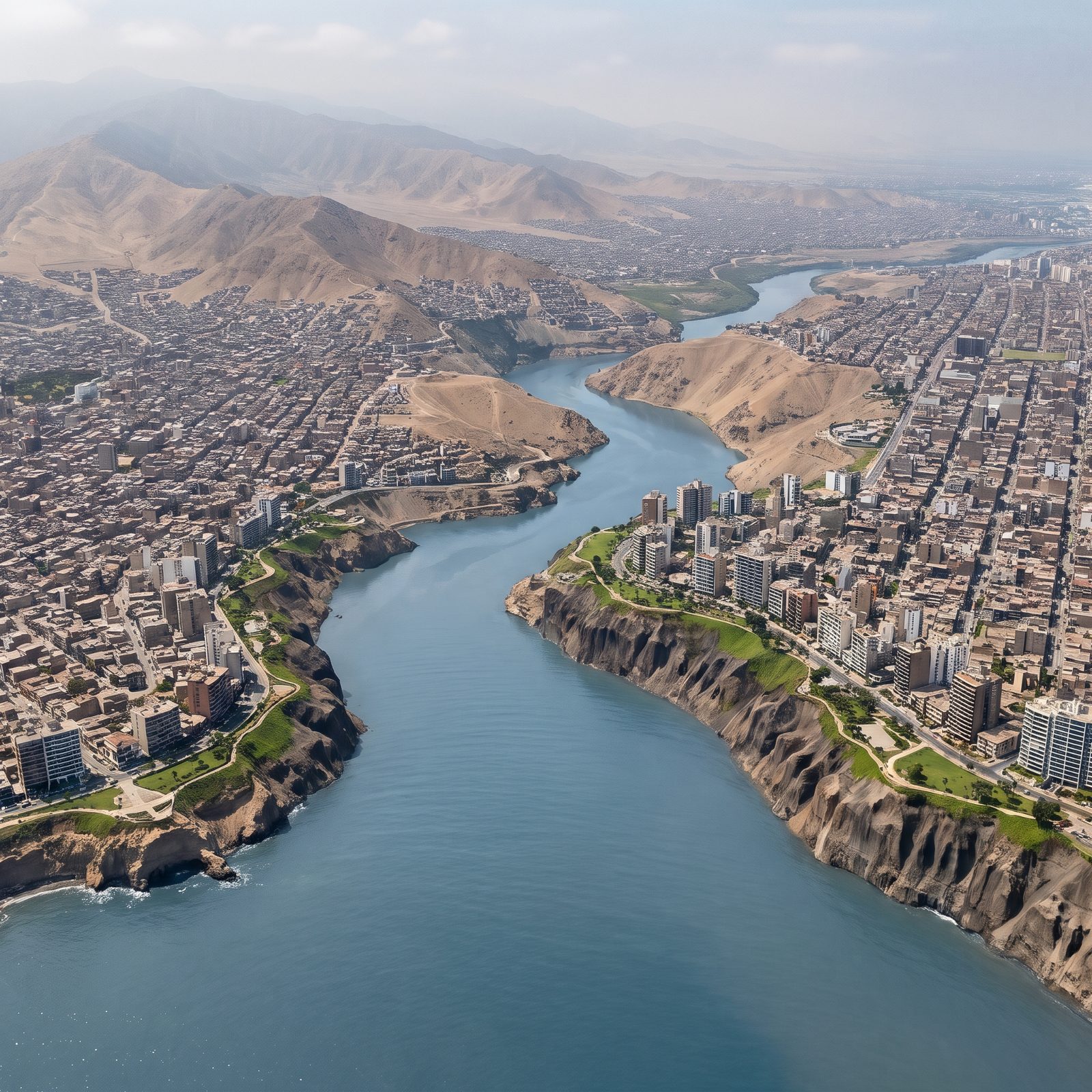
Lima has an unusual defense: it’s a desert city perched on cliffs, so the ocean has to climb to get it.
At 200 feet, the Pacific scales the Costa Verde bluffs and pushes into a single river valley — one wide inlet carved between the bare desert headland and the city. Water winds inland along that one corridor while the neighborhoods on either side stay dry on their higher ground, and the green clifftop parks of Miraflores hold their edge above the coastal road. One clean cut, not patchy flooding. A city split by a single inlet rather than swallowed whole, and far more survivable than the flat deltas further south.
35. London, The Thames Estuary Overwhelms the Barrier
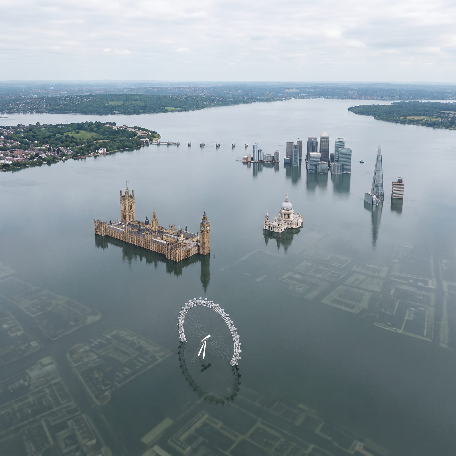
The Thames Barrier was built to close against a storm surge for a few hours. It was never meant to hold back an ocean that simply stopped leaving.
Raise the sea 200 feet and the estuary swallows the whole London basin. Parliament stands in water to its windows. St Paul’s dome floats above a flooded churchyard, and Canary Wharf becomes a cluster of towers in open sea. The one reprieve is London’s quiet geography — the gentle rises of Hampstead and the North Downs survive as green islands, the same high ground people have fled to for a thousand years.
34. Amsterdam, The North Sea Reclaims the Ground the Dutch Spent Centuries Stealing
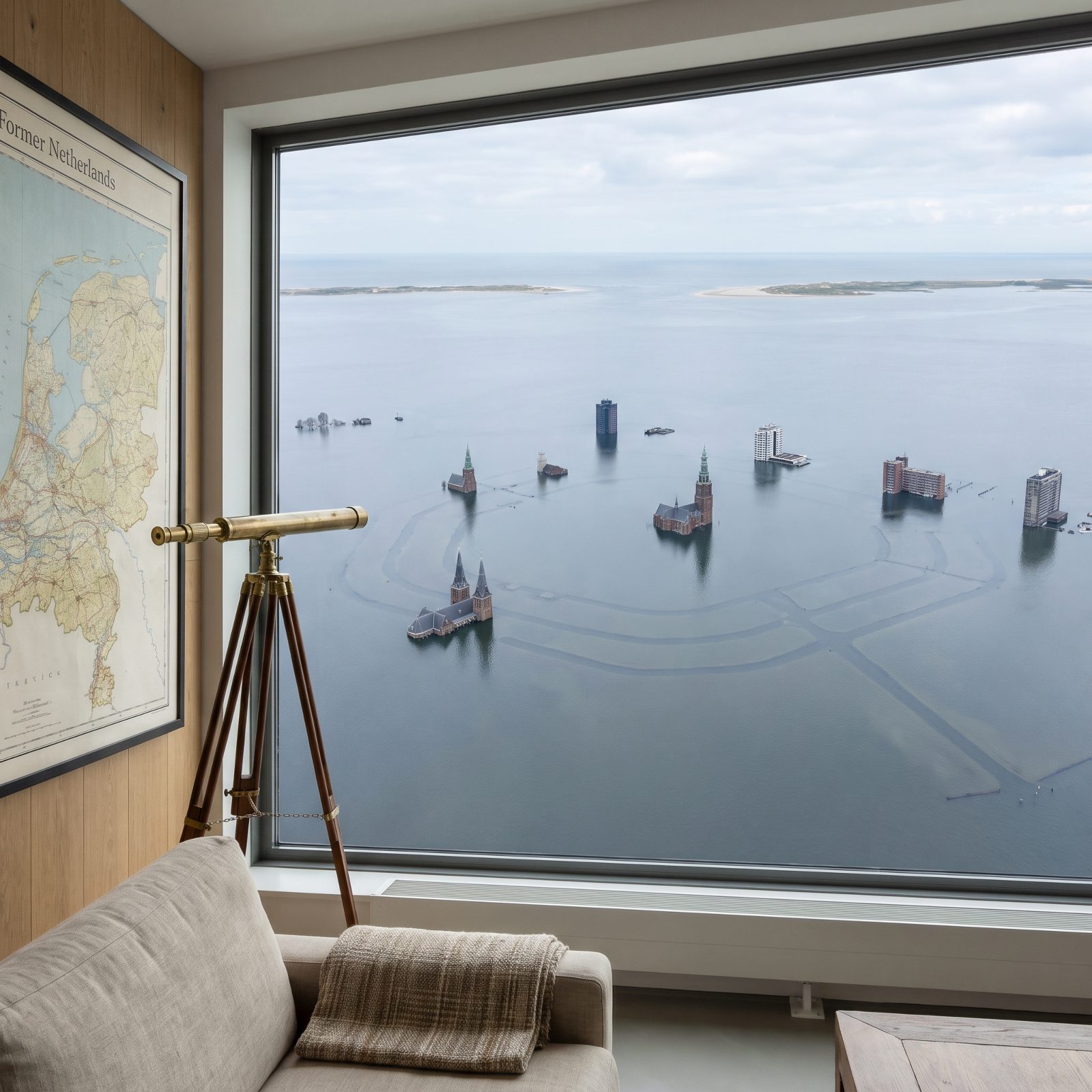
Here’s the cruel joke. Much of Amsterdam already sits below sea level. The Dutch pumped the water out, built dikes, and farmed the mud — one of the great engineering stories on Earth.
A 200-foot rise doesn’t just flood Amsterdam; it erases the whole experiment. The polders, the canal rings, the reclaimed land, all of it returns to the North Sea in one patient tide. The concentric canals that made the city famous would be faint lines under shallow water, and a few old dune ridges would survive as pale islands. Four centuries of borrowed ground, called back.
33. Venice, The Lagoon Finally Takes the City It Always Threatened
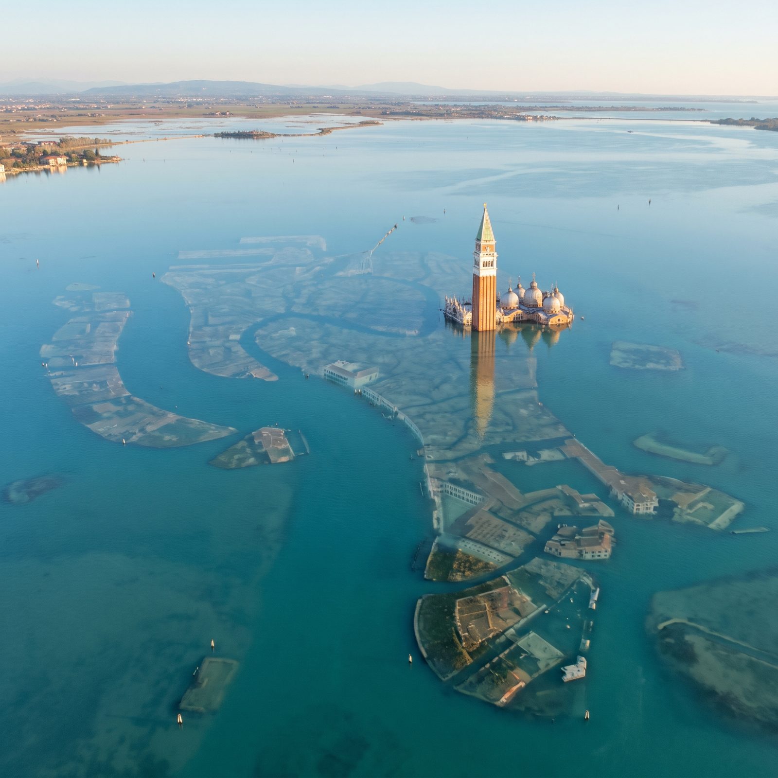
Venice has been losing this argument for a thousand years. It floods on ordinary high tides. The city was always a bargain struck with the water, and the water was always going to collect.
At 200 feet there’s no bargain left. The city goes under, while the mainland Veneto, its towns, fields and wooded shores, still sits dry on the horizon. The campanile of St Mark’s stands alone like a lighthouse over a drowned plan. The basilica lies drowned beside it, its domes a shadow beneath the surface. The Grand Canal becomes a memory traced in shadow beneath clear lagoon water.
32. Lisbon, The Tagus Estuary Widens Around the Seven Hills
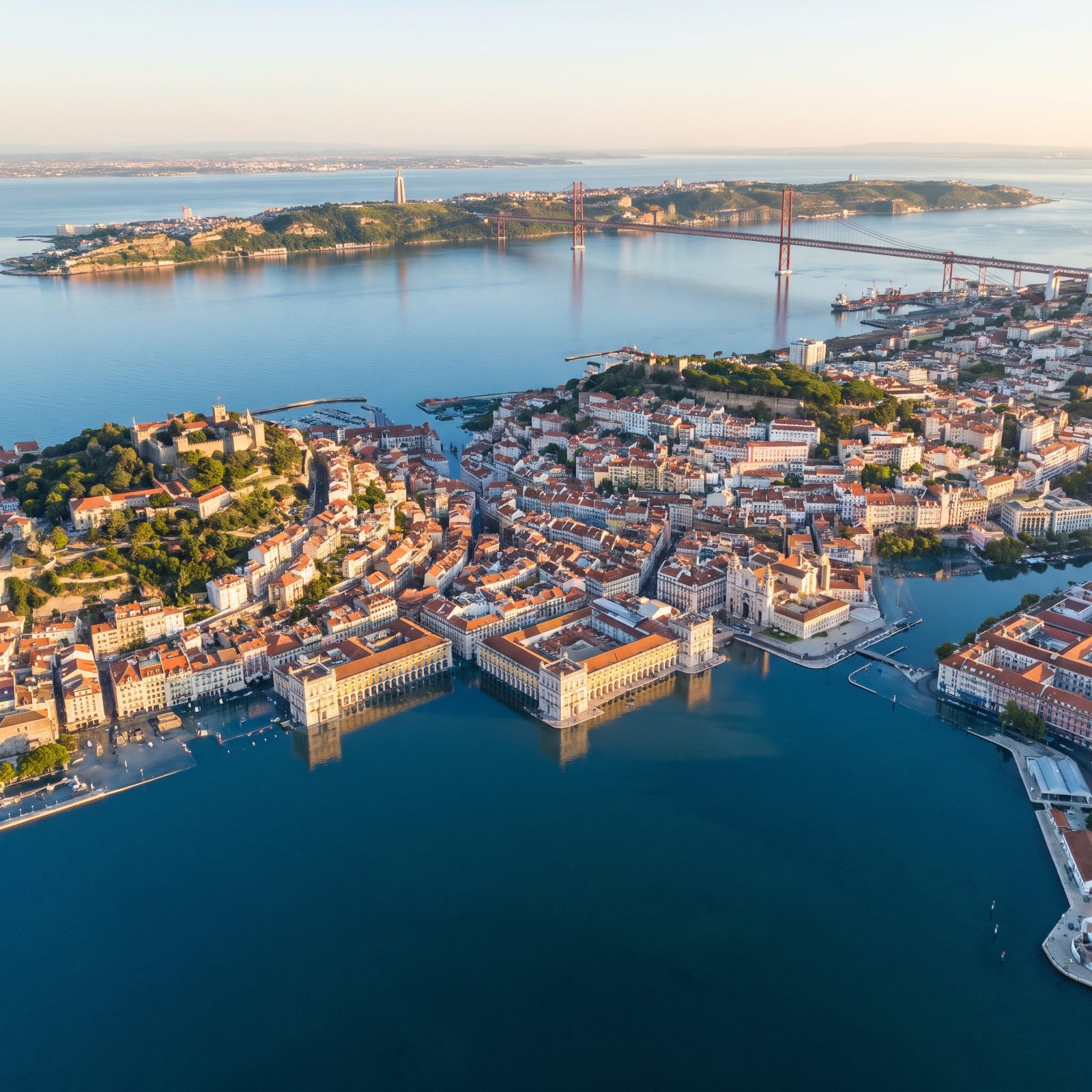
Lisbon’s hills are its luck.
The city sprawls across a famous handful of them, steep enough that the old funiculars groan up the slopes. Raise the Tagus and the water swallows the flat riverside heart — the Baixa, rebuilt after the 1755 earthquake — closing over the arcaded yellow edges of Praça do Comércio and its grid of blocks. And the hills hold. São Jorge castle and the tangled lanes of Alfama ride out the flood as terracotta islands above a widened blue estuary, and the 25 de Abril bridge spans much deeper water. A rare case where the old medieval instinct to build high pays off geologically.
31. Barcelona, The Mediterranean Creeps Toward the Gothic Quarter
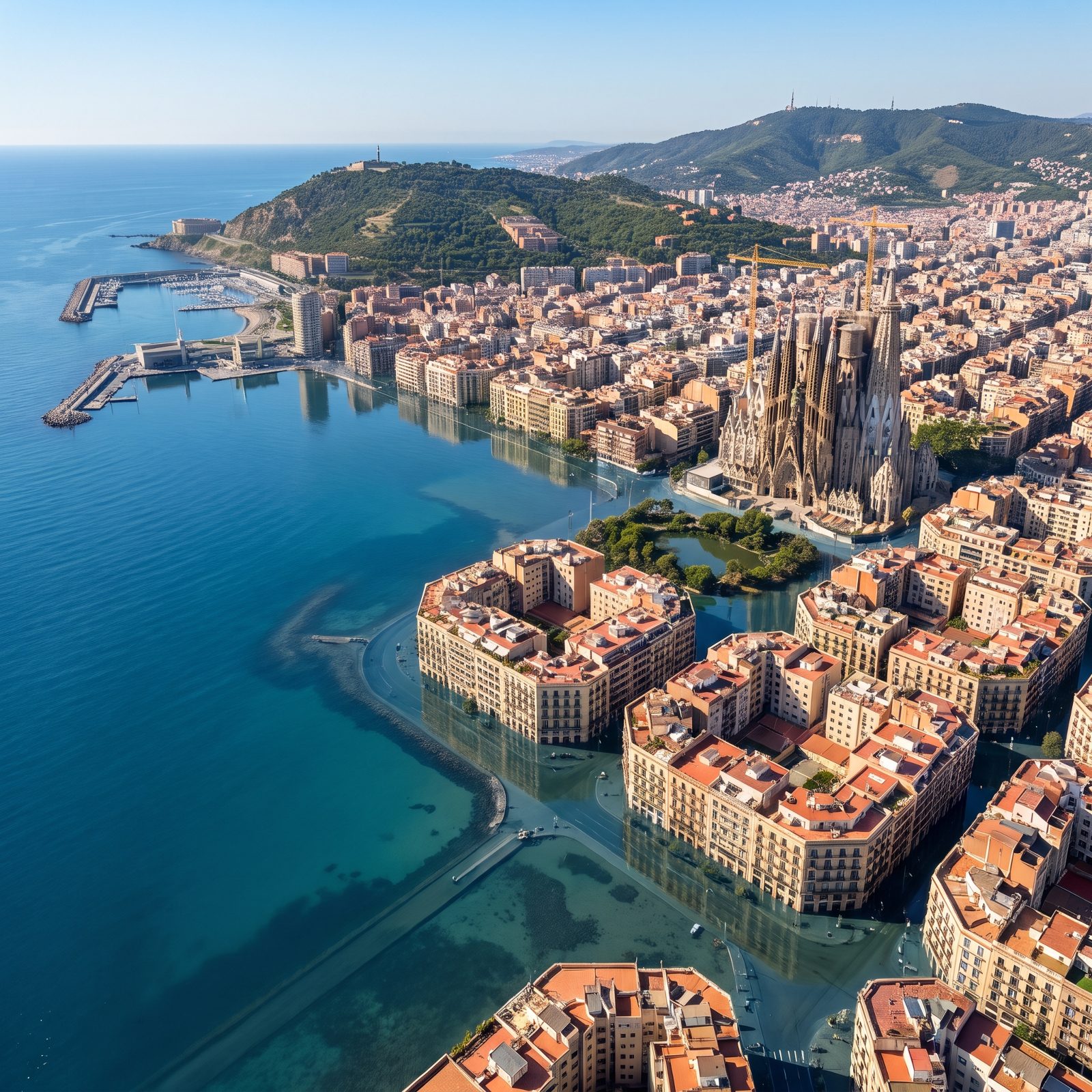
Barcelona doesn’t drown so much as shrink.
The city is pinned between the Mediterranean and the Collserola ridge, built out on a gently sloping coastal plain. A 200-foot rise drinks the beaches and the Barceloneta, and shoves the waterline right up against the Gothic Quarter, and swallows the port’s breakwaters and marina too. The regimented octagonal blocks of the Eixample flood from the sea side inward. But Montjuïc and the hills behind hold firm, and the Sagrada Família, now standing almost on the new shoreline with water lapping at its base, still keeps its spires high above the flood. A city with mountains at its back always has somewhere to retreat to.
30. Naples, The Bay Pushes Inland Beneath the Watching Volcano
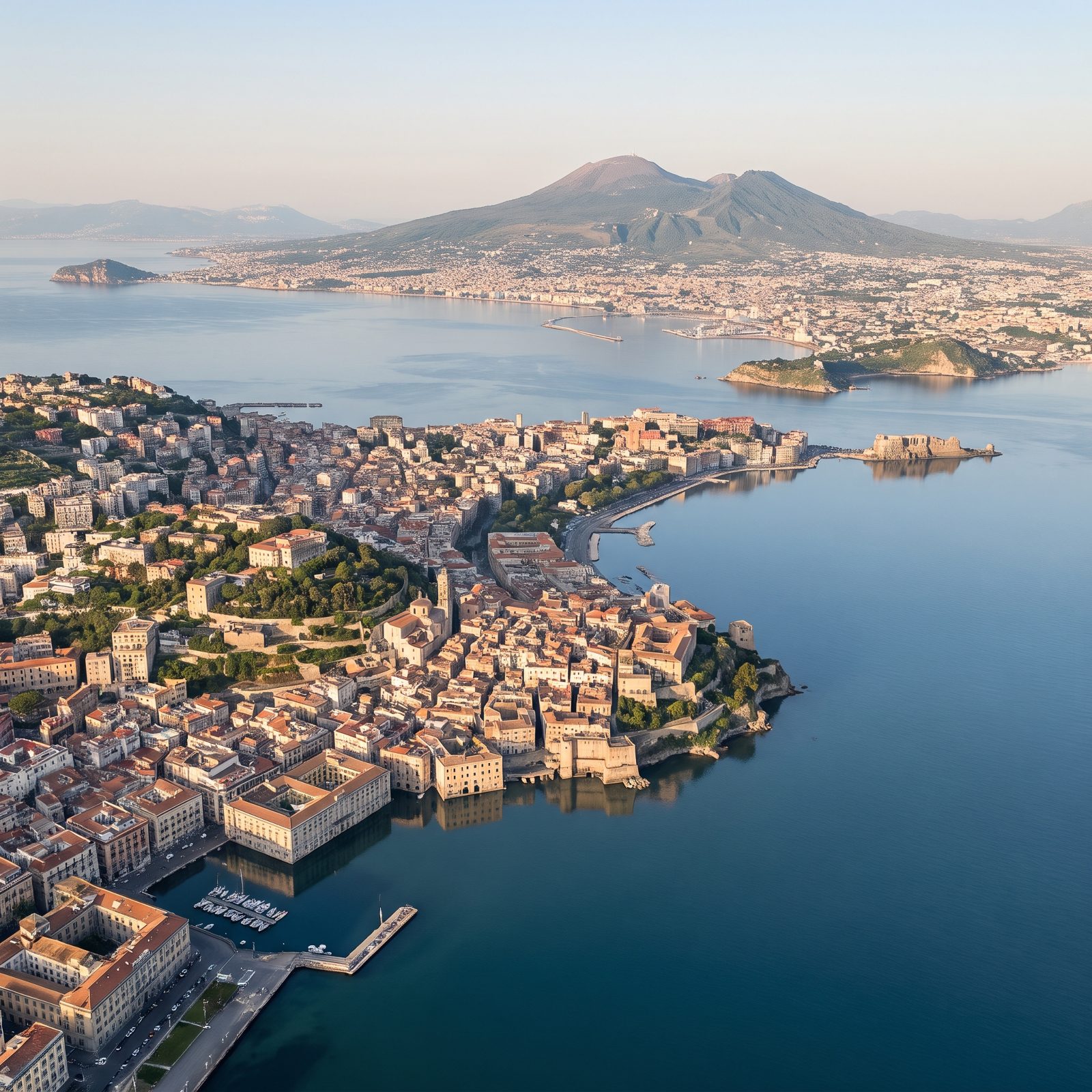
Naples lives in the shadow of a volcano and on the edge of a bay. Pick your hazard.
Raise the sea 200 feet and the bay swallows the port and the low coastal districts, breakwaters, marinas, beaches and waterfront promenade included, while the steep hills of Vomero rise above the drowned lower city. Vesuvius doesn’t care. The cone looms over the shoreline exactly as it has loomed over this coast for thousands of years — outlasting Pompeii, Herculaneum, and every city built since. The green headlands still reach out into a widened bay.
29. Hamburg, The Elbe Estuary Swells Across Northern Germany
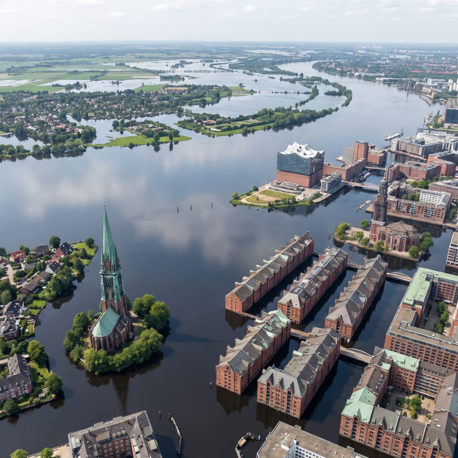
Hamburg already lives on borrowed elevation. Much of the old port sits barely above the tide, and the dikes that hold it there fail completely in this scenario. Push the sea up 200 feet and the Elbe stops being a river — it becomes a broad arm of the North Sea reaching deep into Lower Saxony.
The Speicherstadt warehouse district, all that red brick and iron, drowns to its gables. What’s left are the spires. St. Michael’s and a green-roofed Gothic church, still whole on a tree-lined island, poke up like markers over a city that moved underwater.
28. Saint Petersburg, The Gulf of Finland Reclaims the Neva Delta
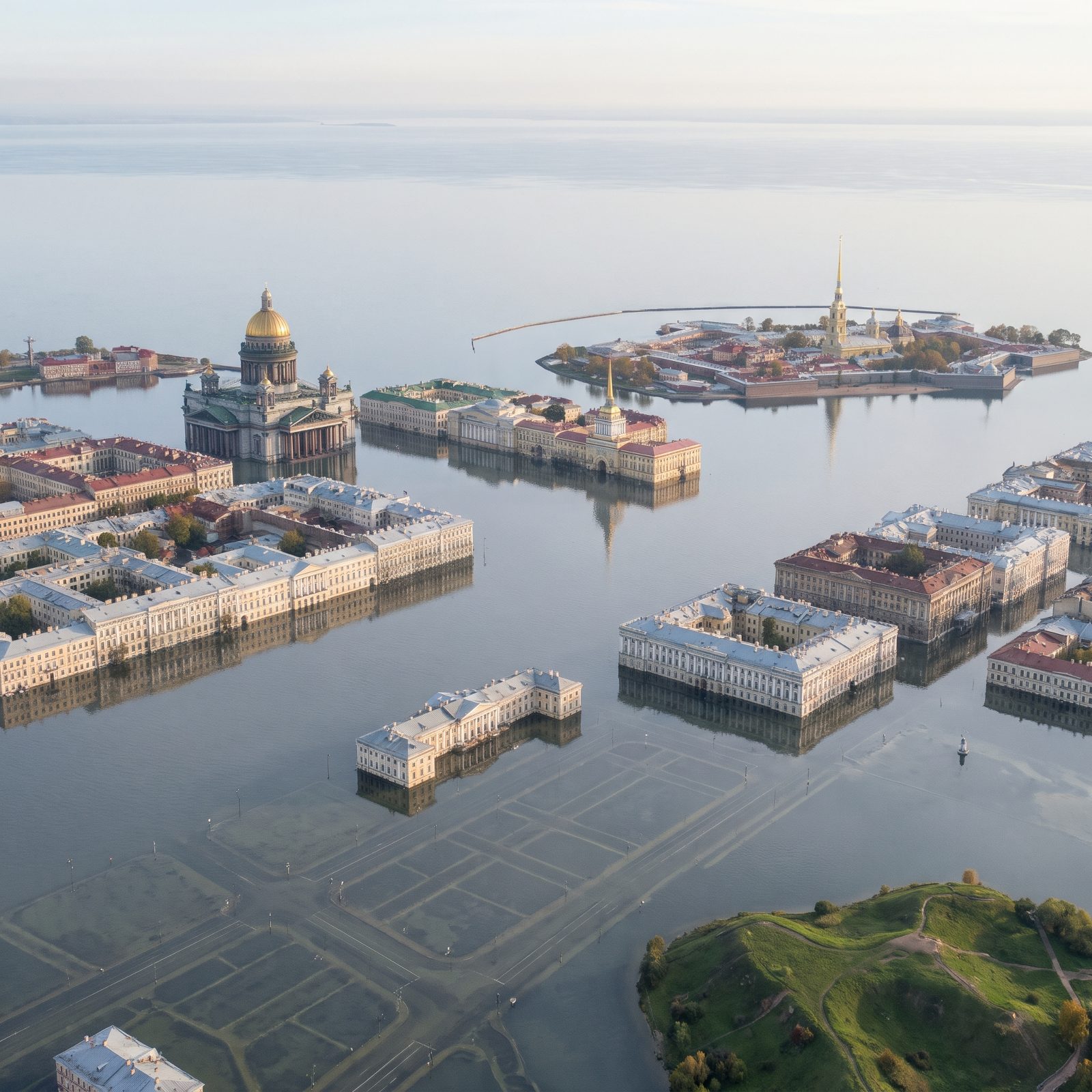
No major city is flatter or more exposed than Saint Petersburg. Peter the Great built his capital on a swampy delta barely a few feet above the Baltic, and it has flooded catastrophically for three centuries. The giant storm barrier finished in 2011 holds back brief surges of a few feet — against a permanent rise of 200 feet, it’s a garden wall facing the sea.
So the Gulf of Finland simply walks in. The squares and streets between the palaces vanish under shallow, clear Baltic water, with lamp posts and road markings still visible beneath the surface. The palace blocks, Saint Isaac’s gilded dome, the Admiralty spire and the needle of the Peter and Paul Fortress still stand whole, mirrored in the flood, turning the Venice of the North into a true city on the water.
27. Istanbul, The Bosphorus Broadens Across Two Continents
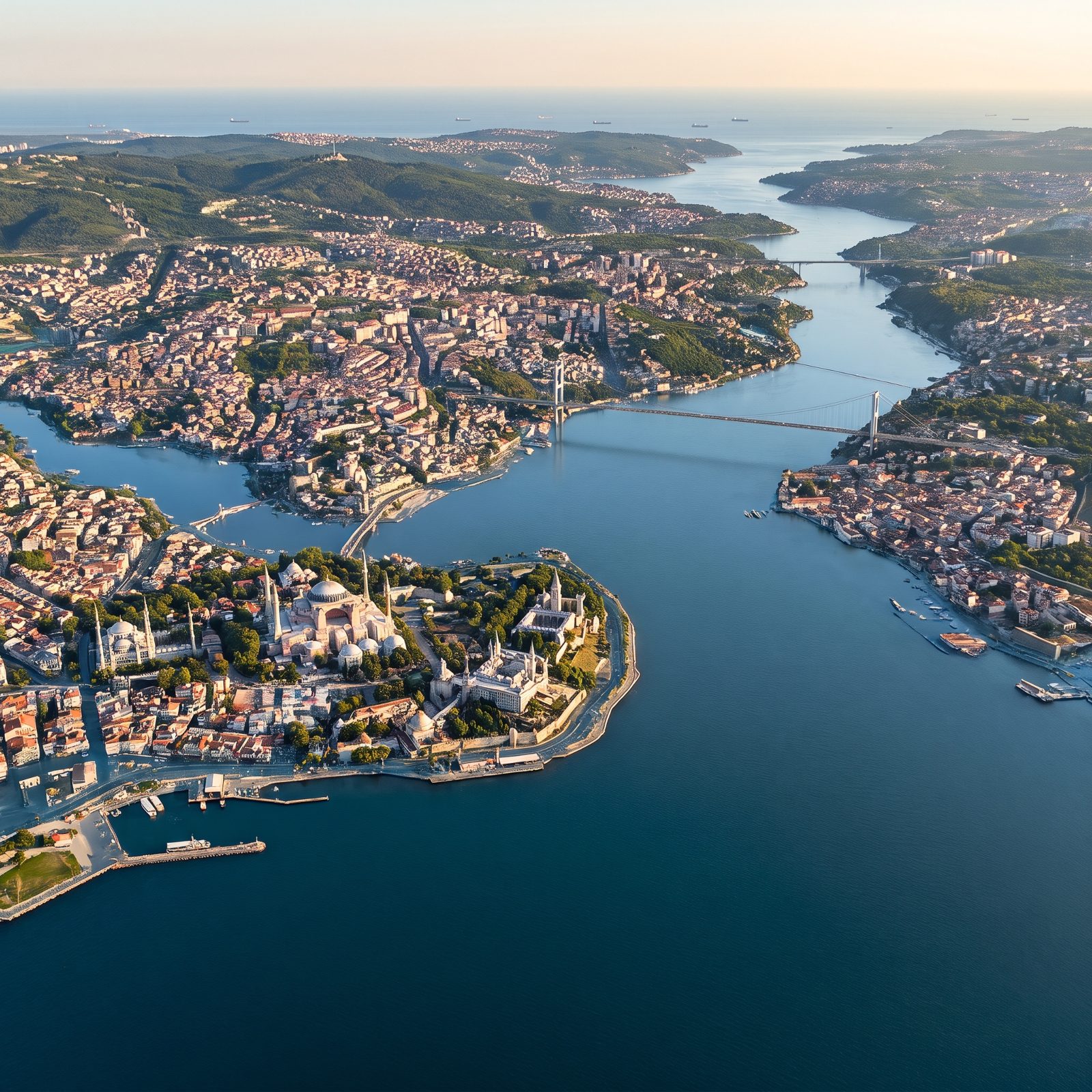
Istanbul’s saving grace is its hills. The old city rose on seven of them, and that’s why this scenario would spare its heart while swallowing its edges.
The Bosphorus is already a drowned river valley, carved during the last ice age and flooded when the seas rose after. Add 200 feet and it would widen again, pulling the Golden Horn and the Sea of Marmara into one broad sheet of water and putting the waterfront palaces and ferry docks under. Hagia Sophia, perched on its ridge, looks across a far wider strait to the hills of the Asian shore.
26. Stockholm, The Baltic Multiplies the City’s Islands
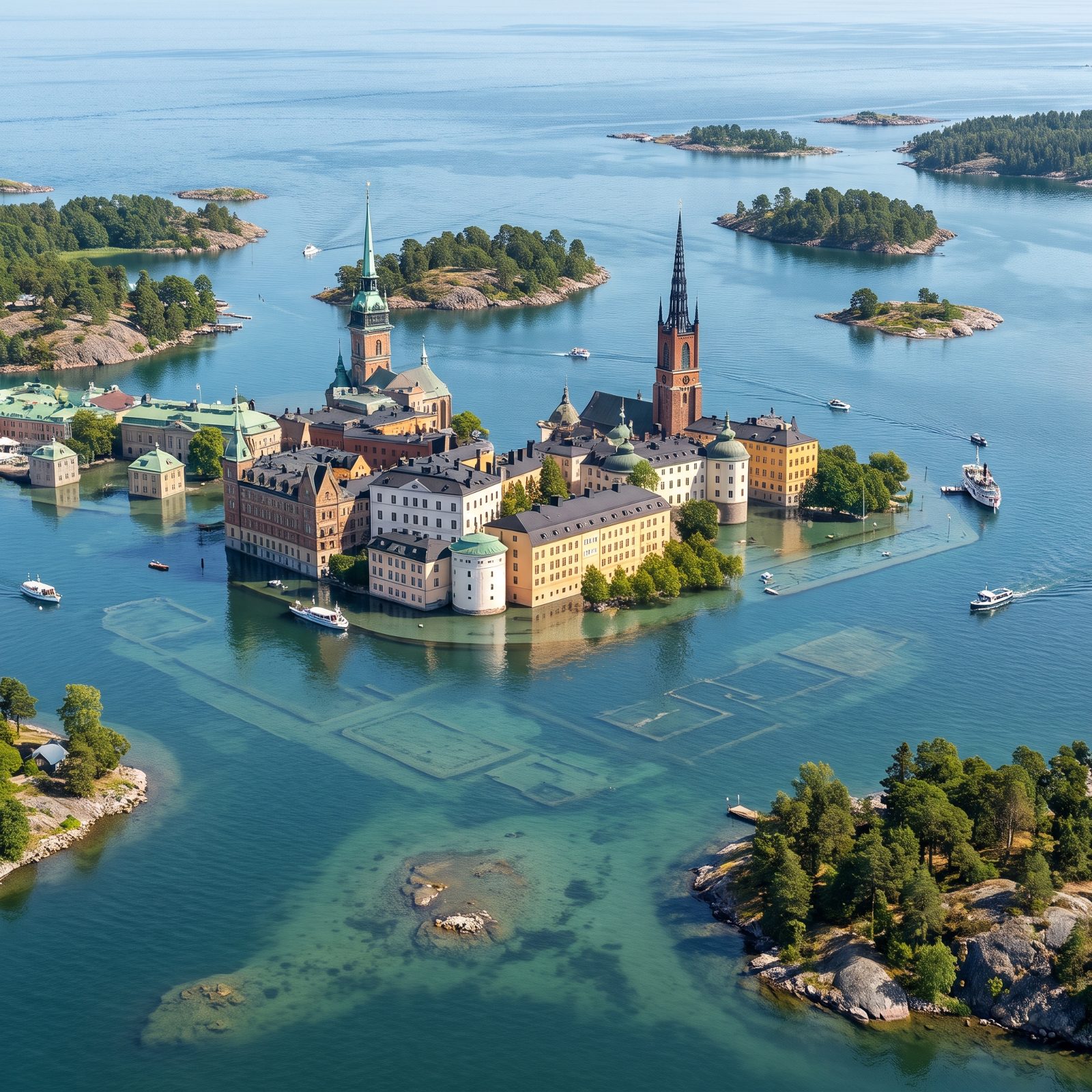
Stockholm is already stitched across fourteen islands, so flooding it is less a drowning and more a reshuffle. Raise the Baltic 200 feet and the low channels swallow everything between the hills, leaving a scatter of rocky knolls where a city used to connect.
Gamla Stan — the old town, with its narrow medieval lanes and ochre facades — loses its ground floors to clear green water. The granite outcrops that Swedes have always built on become the new coastline, pine trees and all. If any big city is built to come through partial submersion with its character intact, it’s this one.
25. Alexandria, Egypt’s Mediterranean Jewel Goes Under

Alexandria barely survives the sea it has today. Founded by Alexander in 331 BC, it sits on the flat edge of the Nile Delta, some of the most low-lying and sinking land on Earth. Parts of it already flood during ordinary storms, and the ancient royal quarter — Cleopatra’s palace included — has sat underwater in the harbor for roughly sixteen centuries.
A 200-foot rise finishes the job. The Corniche disappears. The delta behind the city turns into a shallow inland sea reaching deep into Egypt, and the modern Bibliotheca Alexandrina and the Qaitbay Citadel, built on the ruins of the ancient lighthouse, stand almost alone above the water. A city that already lost one self to the Mediterranean loses the second.
24. Lagos, The Atlantic Overtakes the Lagoon Megacity
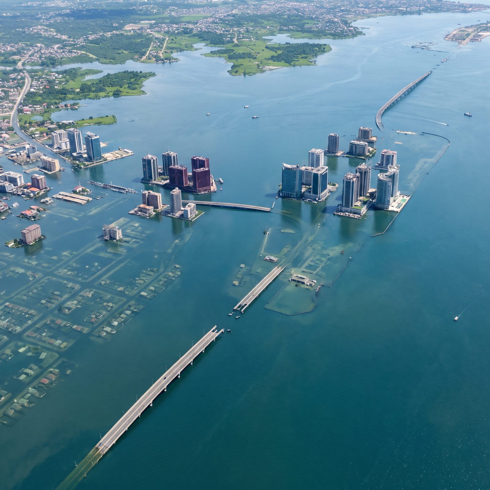
Lagos is barely holding its ground now. Large parts of the city sit under three feet of elevation, which is why coastal erosion already swallows homes along the Bar Beach. Developers built the Eko Atlantic district on reclaimed land behind a sea wall, betting against the ocean.
That bet loses badly at 200 feet. The lagoon swells and swallows whole low-lying neighborhoods, whose streets and rooftops now show through shallow water, and it merges with the Atlantic into one continuous expanse of open sea. The glass towers of Victoria Island rise in clusters straight out of open water, with no dry land left beneath them.
23. Dakar, The Atlantic Pinches the Cap-Vert Peninsula
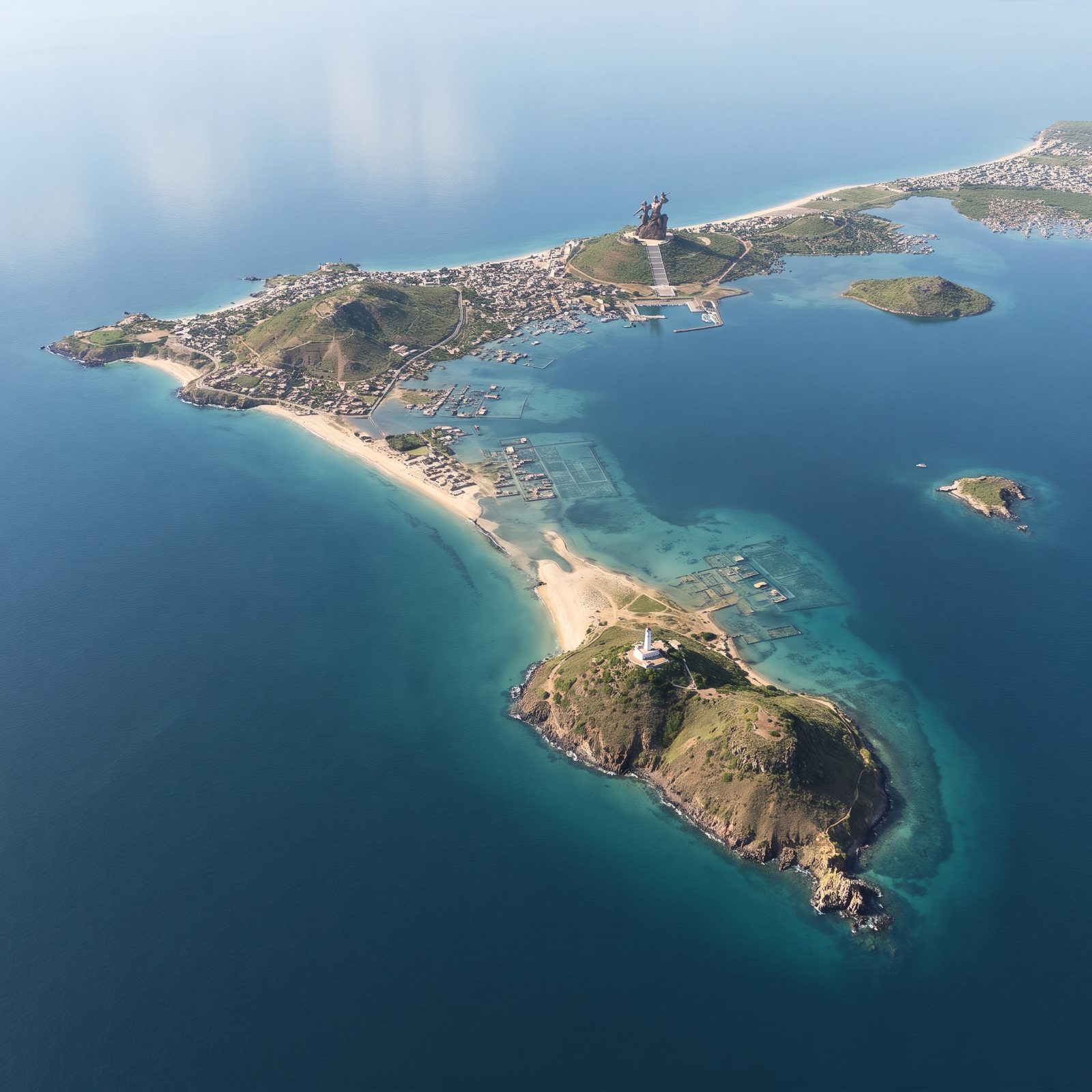
Dakar clings to the westernmost tip of Africa, a hammer-shaped peninsula of old volcanic rock and low sand flats. That geology splits its fate in two.
Push the Atlantic up 200 feet and the low flats around Cap-Vert drown, leaving only a thin sand neck and its dirt road tying the hills to the mainland. The basalt hills survive. The African Renaissance Monument, a 160-foot bronze colossus that looms over the headland, stands high and dry on its green hill above crowded rooftops and a busy harbor, while far to the south a white lighthouse crowns a separate rocky island, joined to the rest only by a long sand spit, while a small offshore islet shrinks to a rocky nub. Where the coast was low, the ocean takes it. Where ancient lava built high ground, the hills endure.
22. Cape Town, Table Mountain Towers Over a Rewritten Coast
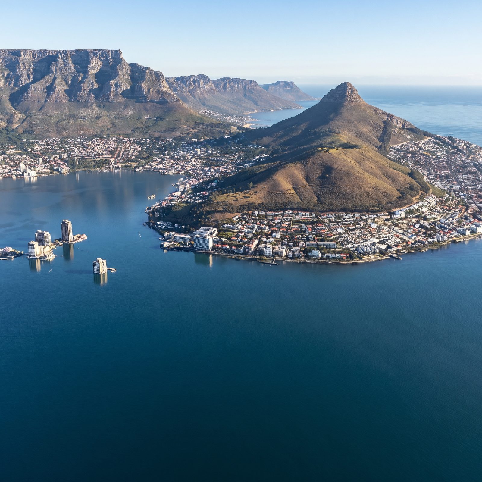
Cape Town has the best insurance policy of any city here, and its name is Table Mountain. The flat-topped sandstone massif stands over 3,500 feet, so it shrugs off a 200-foot rise without noticing.
The damage happens at its feet. The City Bowl, the harbor, and the V&A Waterfront drown as the Atlantic climbs the lower slopes. What happens behind the mountain is stranger still. The low, sandy Cape Flats, where much of the population lives, floods into a broad shallow channel, briefly cutting the mountain off from the rest of Africa.
The mountain doesn’t move. Everything around it becomes a coastline no one has ever seen.
21. Dubai, Palm Islands and Glass Towers Stand in Deep Water
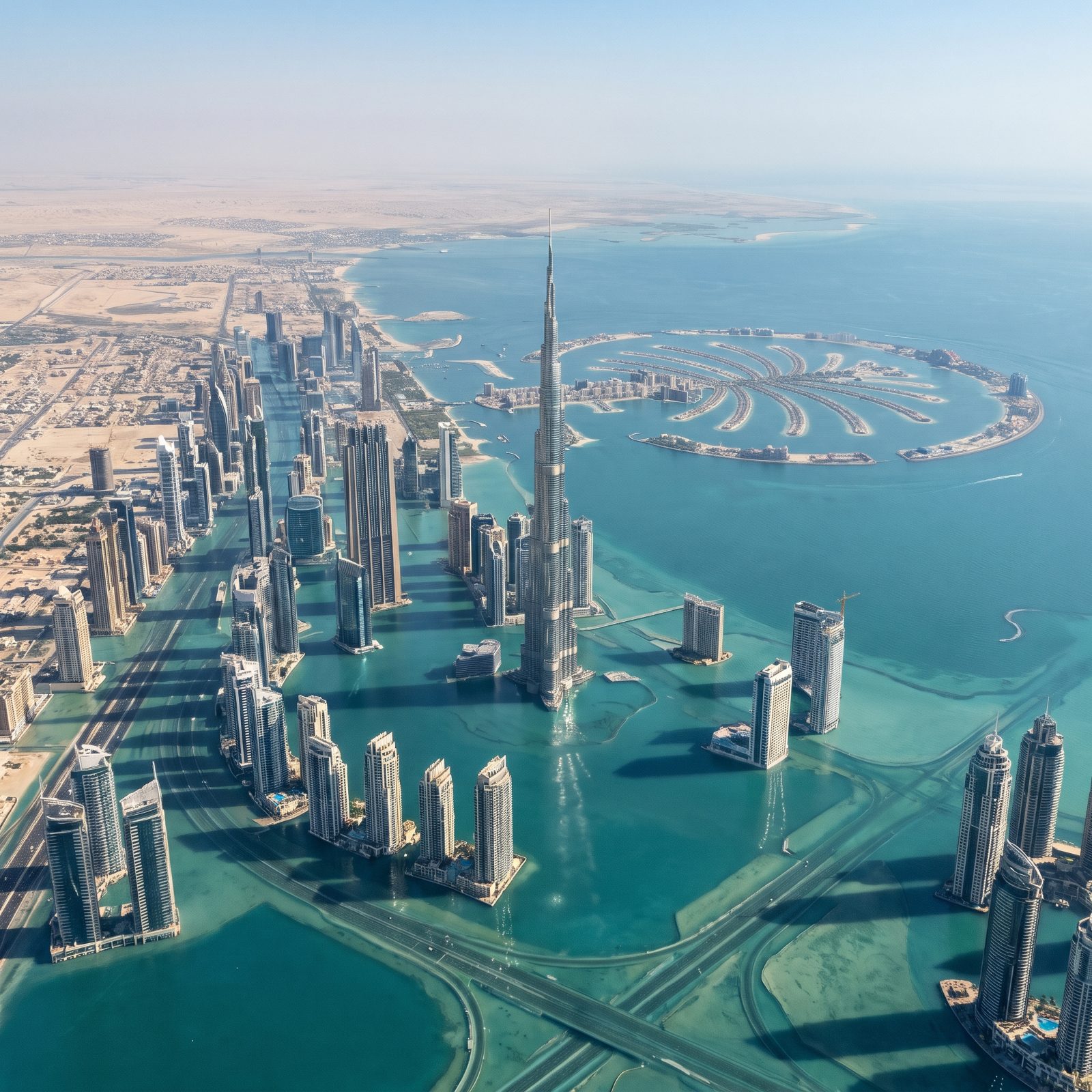
Dubai reclaimed land from the sea. The sea, in this scenario, takes it all back with interest.
The Palm Jumeirah, that famous palm-shaped island built from dredged sand, barely rises a few feet above the Gulf. In this scenario it is simply gone, its fronds and crescent erased beneath the Gulf, and the flood swallows the coastal strip of towers and roads and the flat city behind it.
The Burj Khalifa, all 2,700 feet of it, keeps its head well above water. But it stands as a lone spike in a drowned skyline, the ambition of a city that reached upward and outward on ground the ocean always had a claim to.
20. Karachi, The Arabian Sea Spreads Across the Indus Lowlands
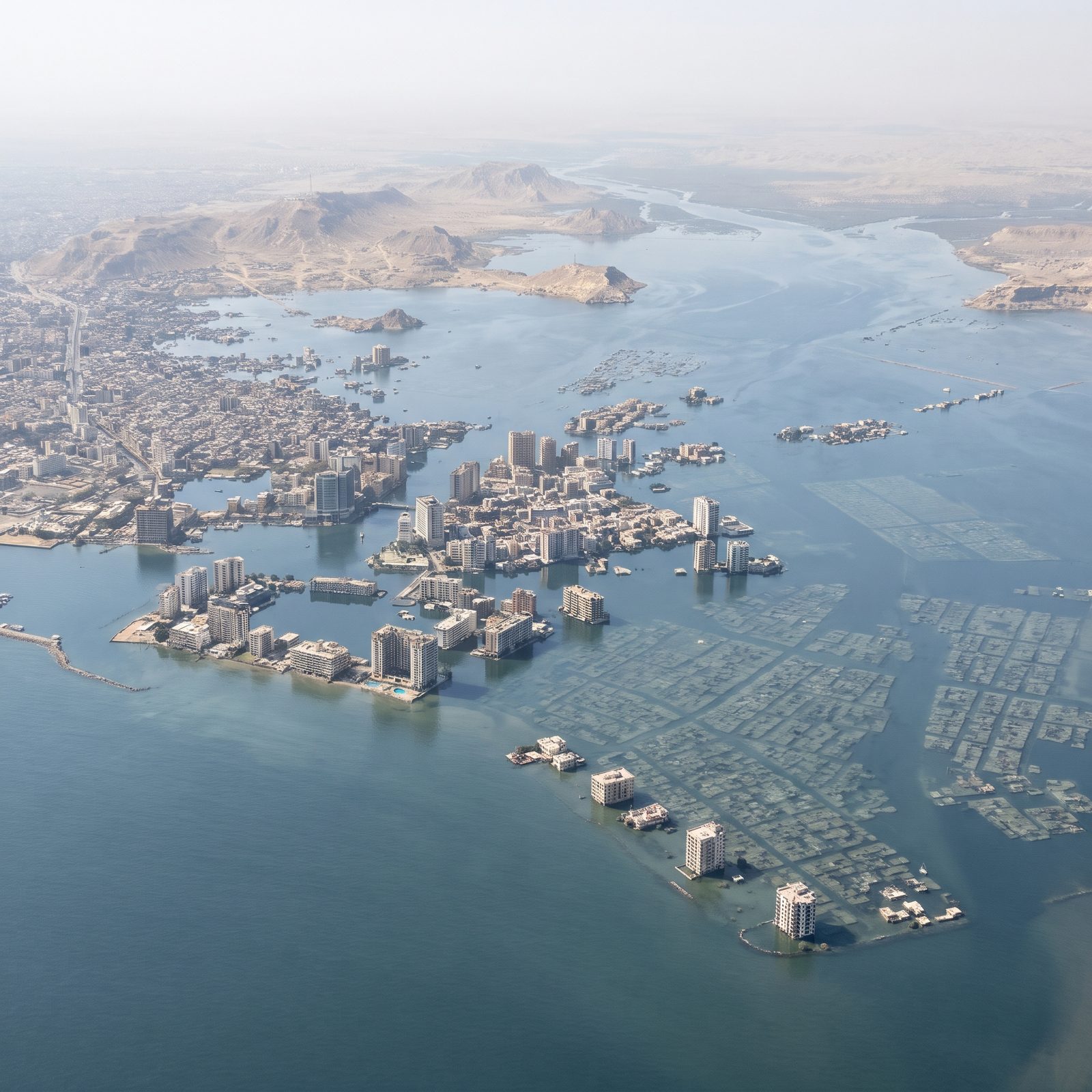
Karachi has one of the biggest exposures of all. A megacity of many millions sprawls across the flat delta where the Indus meets the Arabian Sea, and flat delta land is the first thing the ocean claims.
Raise the sea 200 feet and the water doesn’t stop at the harbor. It spreads across the lowlands, merges with the drowned Indus delta, and reaches far inland into Sindh, one of the most densely farmed and crowded regions anywhere. The port vanishes. The city center stands waist-deep.
19. Mumbai, The Seven Islands Reemerge as a Drowned Archipelago
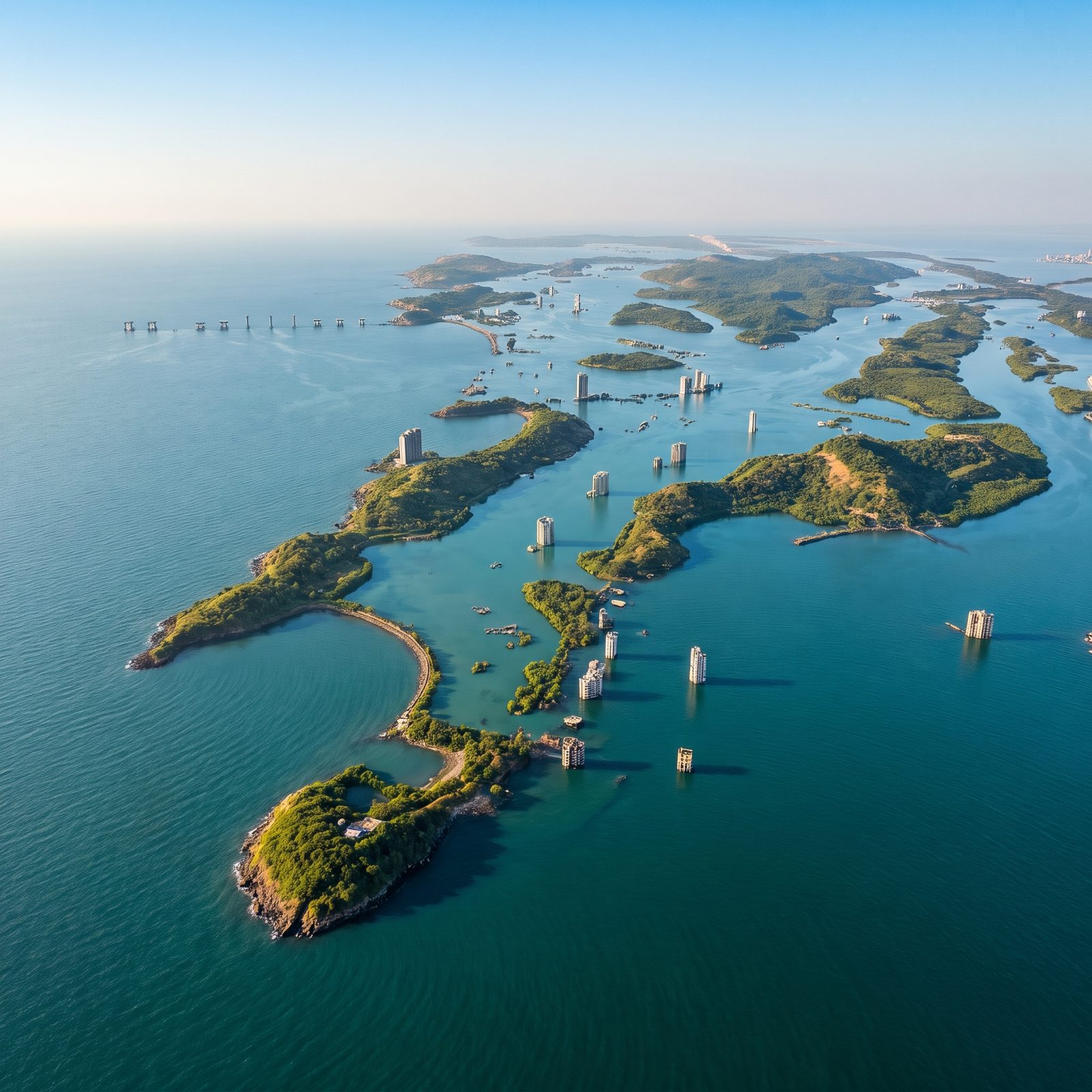
Mumbai was never meant to be one landmass. It started as seven islands the British stitched together over centuries of landfill, and a 200-foot rise simply hands that geography back by drowning the low reclaimed neck that joins the old islands.
What survives sticks up on bedrock. Malabar Hill becomes a green island again, while Marine Drive — that famous curve of streetlights locals call the Queen’s Necklace — sinks without a trace beneath the bay, and the upper floors of the skyline poke out like a scattering of concrete atolls.
18. Kochi, The Arabian Sea Expands Through Kerala’s Backwaters
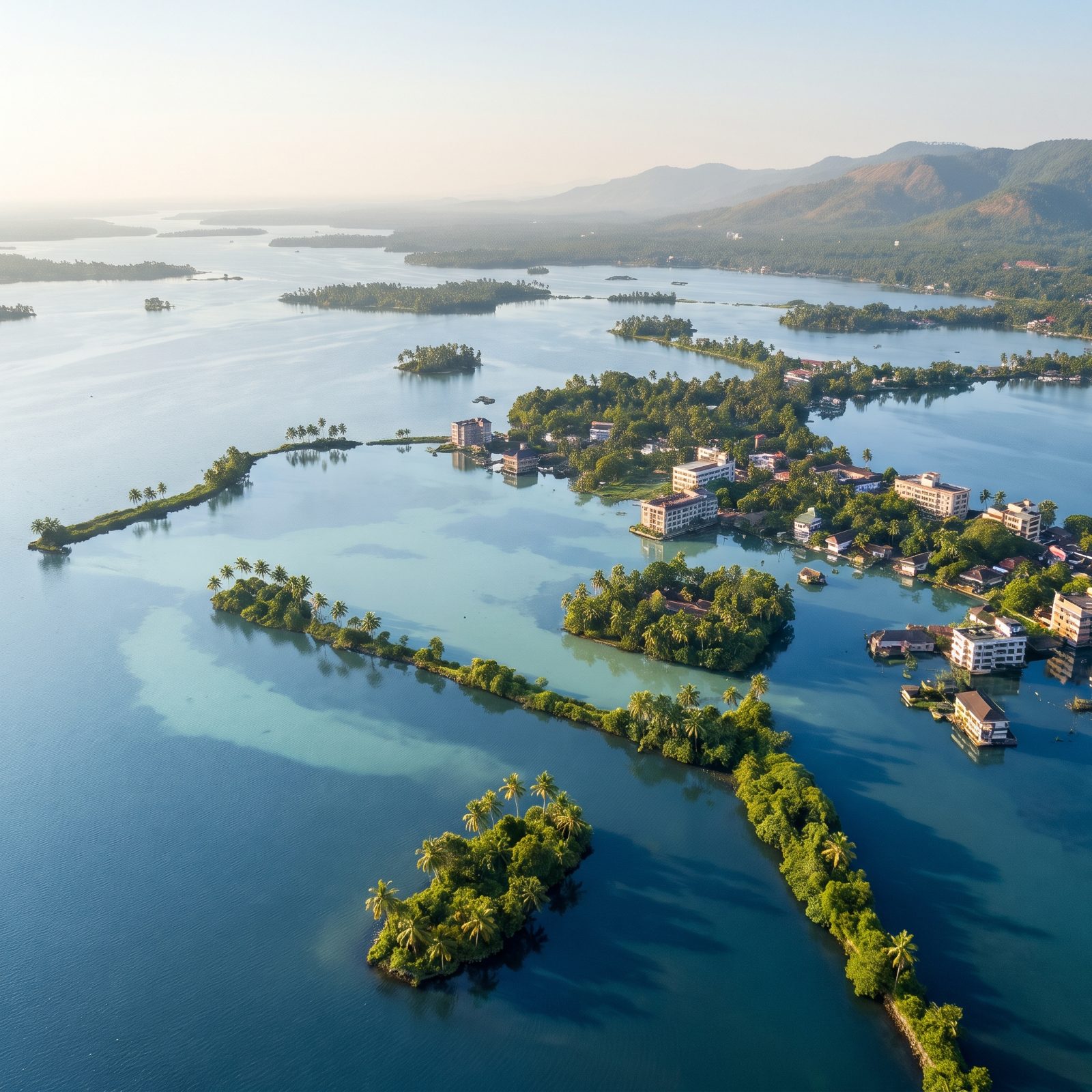
Kochi already lives half in the water. Its backwaters, lagoons and reclaimed spits sit barely above the Arabian Sea, so it barely puts up a fight.
Push the sea up just a few feet and the lazy network of canals swells into broad lagoons. Willingdon Island, built from dredged mud in the 1930s, is left with water lapping at its doorsteps, Fort Kochi’s multi-storey buildings stand with their ground floors awash, and the place turns back into what Kerala geography always threatened: scattered palm-lined islands and spits in a shining inland sea.
17. Chennai, The Bay of Bengal Advances Across the Coastal Plain
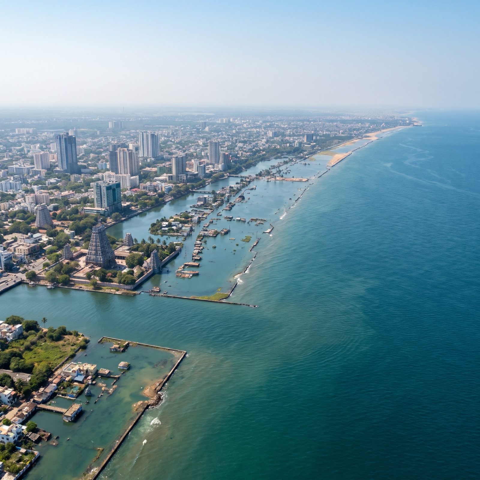
Chennai’s problem is that it is almost perfectly flat. The coastal plain of Tamil Nadu gives the sea very little to climb over, so even a modest rise doesn’t stay on the beach. It spreads.
Marina Beach, one of the longest urban beaches on Earth, vanishes early. The Adyar and Cooum rivers back up into broad bays, and a shallow lagoon forms behind the old shoreline, swallowing the flat city behind it. Temple gopurams on ordinary flat ground would stand among neighbouring buildings, with the lagoon’s edge lapping at the lowest blocks nearby.
16. Malé, The Entire Island Capital Vanishes Beneath the Waves
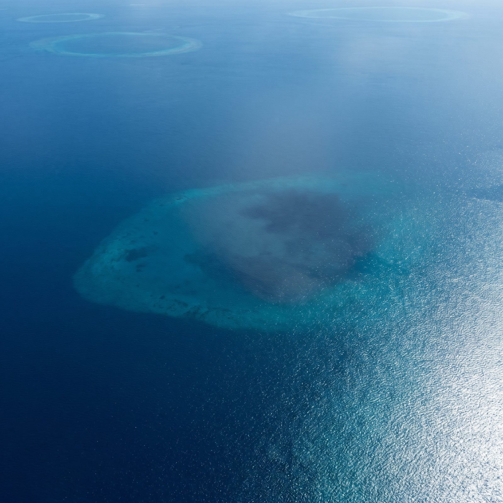
There is no drama here. No surviving skyline, no stubborn hilltop. Malé just goes.
The Maldivian capital is one of the most crowded cities on Earth, packed onto an island whose highest natural point sits a few feet above sea level. A rise of 200 feet doesn’t reshape Malé — it deletes it, and everything you’d see is clear tropical water over a faint pale smudge where a city used to be.
15. Bangkok, The Gulf of Thailand Reaches the City Center
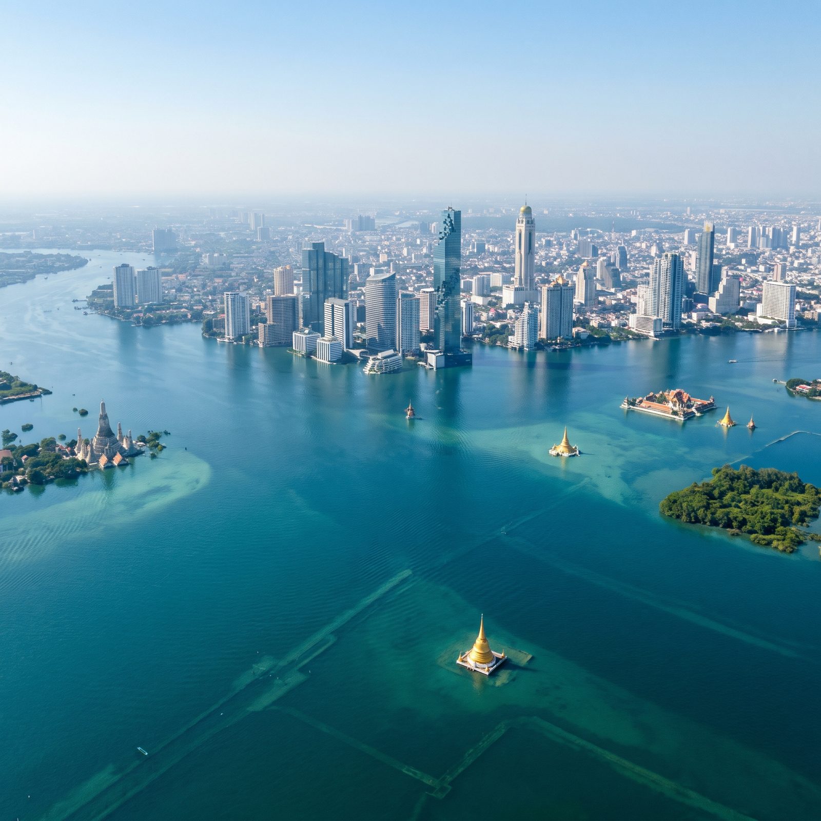
Bangkok is sinking without any help from us. The city rests on soft delta clay and pumps its own groundwater, dropping an inch or more some years, so the sea doesn’t even need to rise much to win.
Give it 200 feet and the Gulf of Thailand laps right up against the city center, and pushes far up the Chao Phraya, drowning the flat hinterland to the horizon. The glittering towers of Silom and Sukhumvit become a continuous waterfront of glass. Whole temples, their golden stupas still sitting on raised platforms and sacred mounds, catch the light like gilded islands afloat on a calm bay, and the klongs — those famous canals — simply merge into the sea that fed them.
14. Singapore, The Island Nation Loses Its Coastal Heartlands
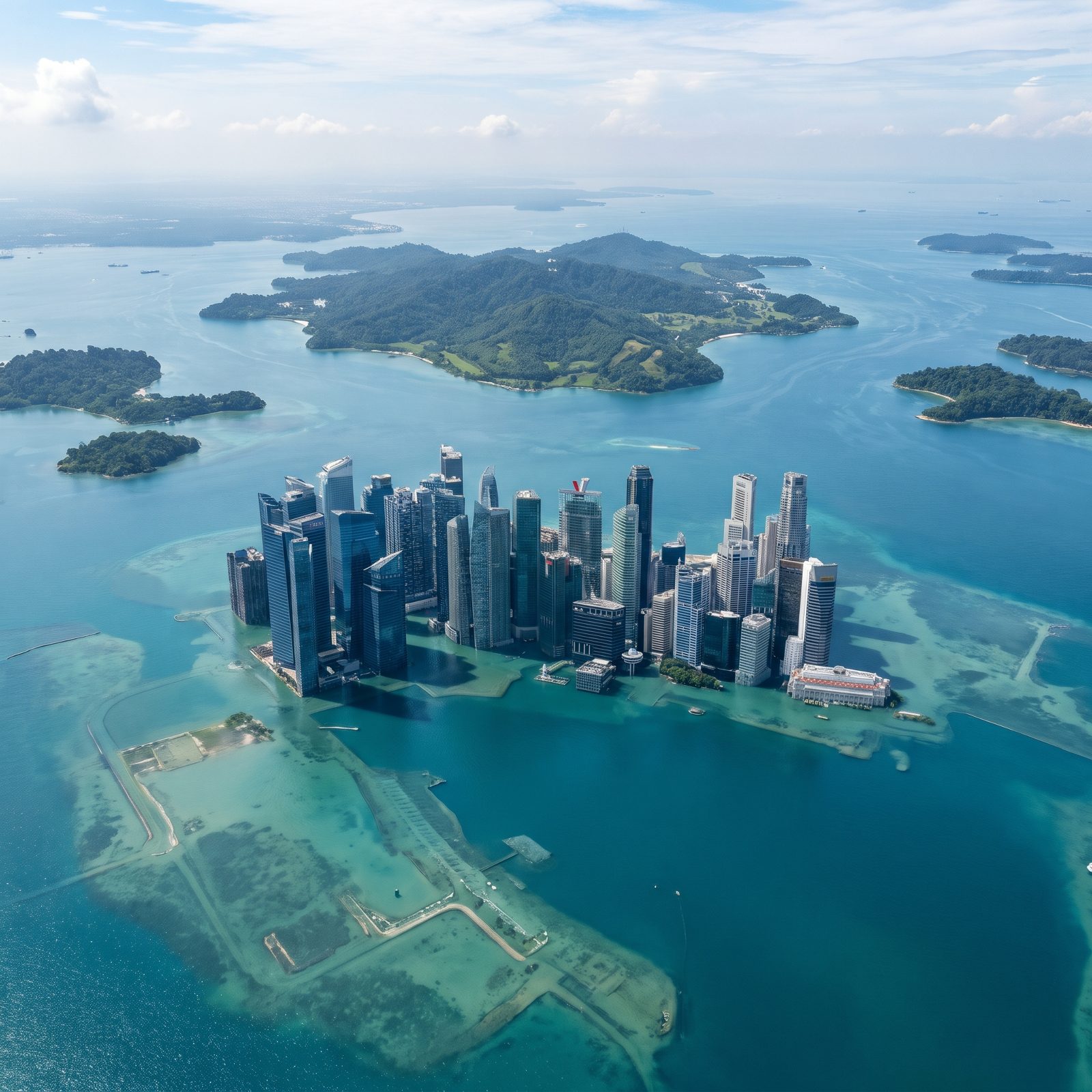
Singapore spent decades adding land. The sea would spend one bad geological chapter taking it back, and then some.
Much of modern Singapore stands on reclaimed coastline, and Marina Bay sits directly on it, and here that showpiece district is gone, its reclaimed bayfront, parks and promenades all lying beneath shallow turquoise water. The downtown towers rise straight out of the sea, their flooded bases standing in water with no dry shoreline left, while lush green hills stand apart as separate islands offshore across the strait.
13. Jakarta, The Java Sea Engulfs the Sinking Capital
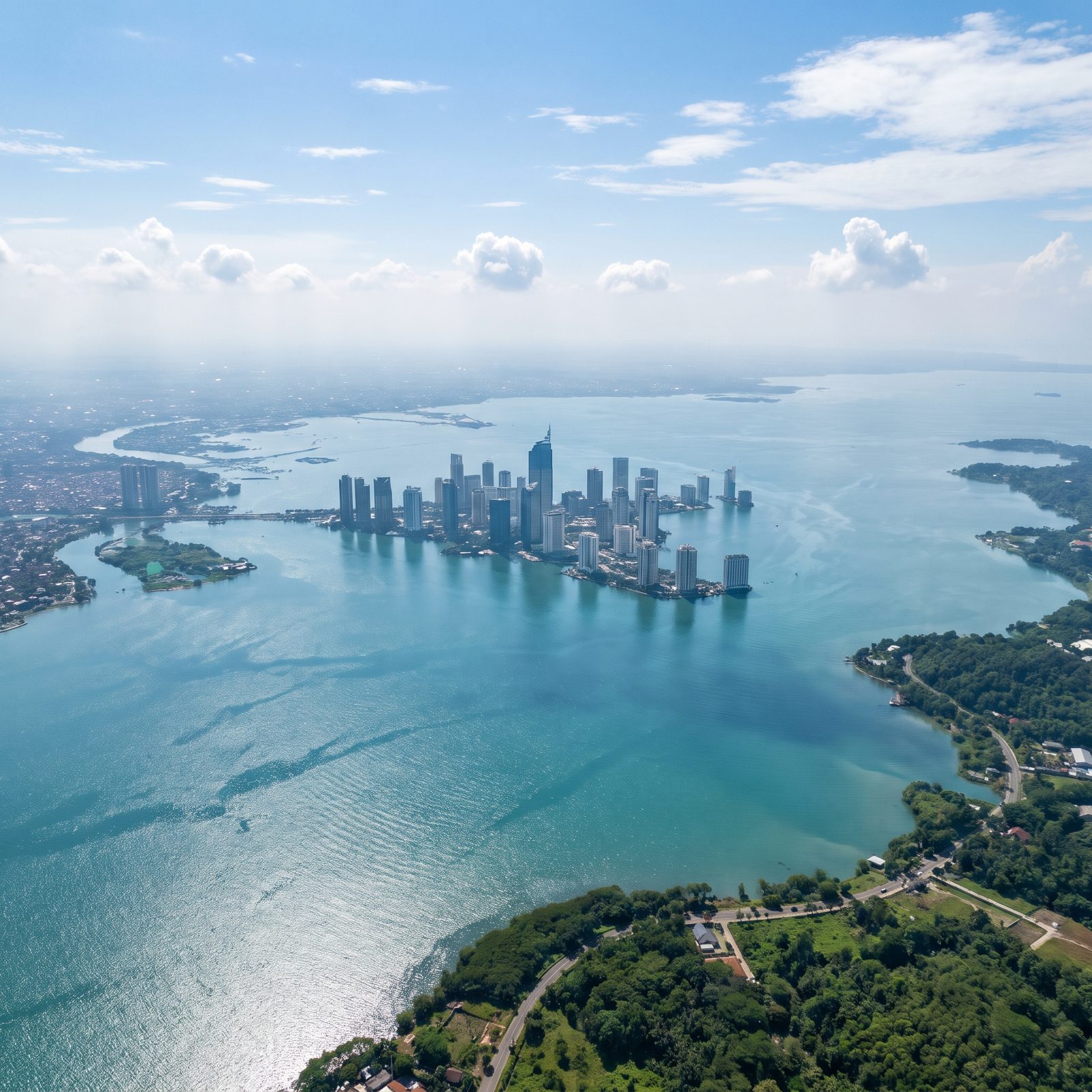
No major city is sinking faster. Parts of northern Jakarta drop several inches a year as the ground compacts and the aquifers below get drained dry, and the place is already losing a slow race with the Java Sea.
A 200-foot rise ends that race entirely. The central business district towers stand as a drowned cluster in open water, while the dense low-lying neighborhoods along the shore and the flat plain behind them vanish, leaving only distant green hills rising from the sea. Indonesia is already moving its capital to Borneo, which tells you how the trend reads to the people who actually live there.
12. Manila, Manila Bay Spreads Across the Metropolitan Lowlands
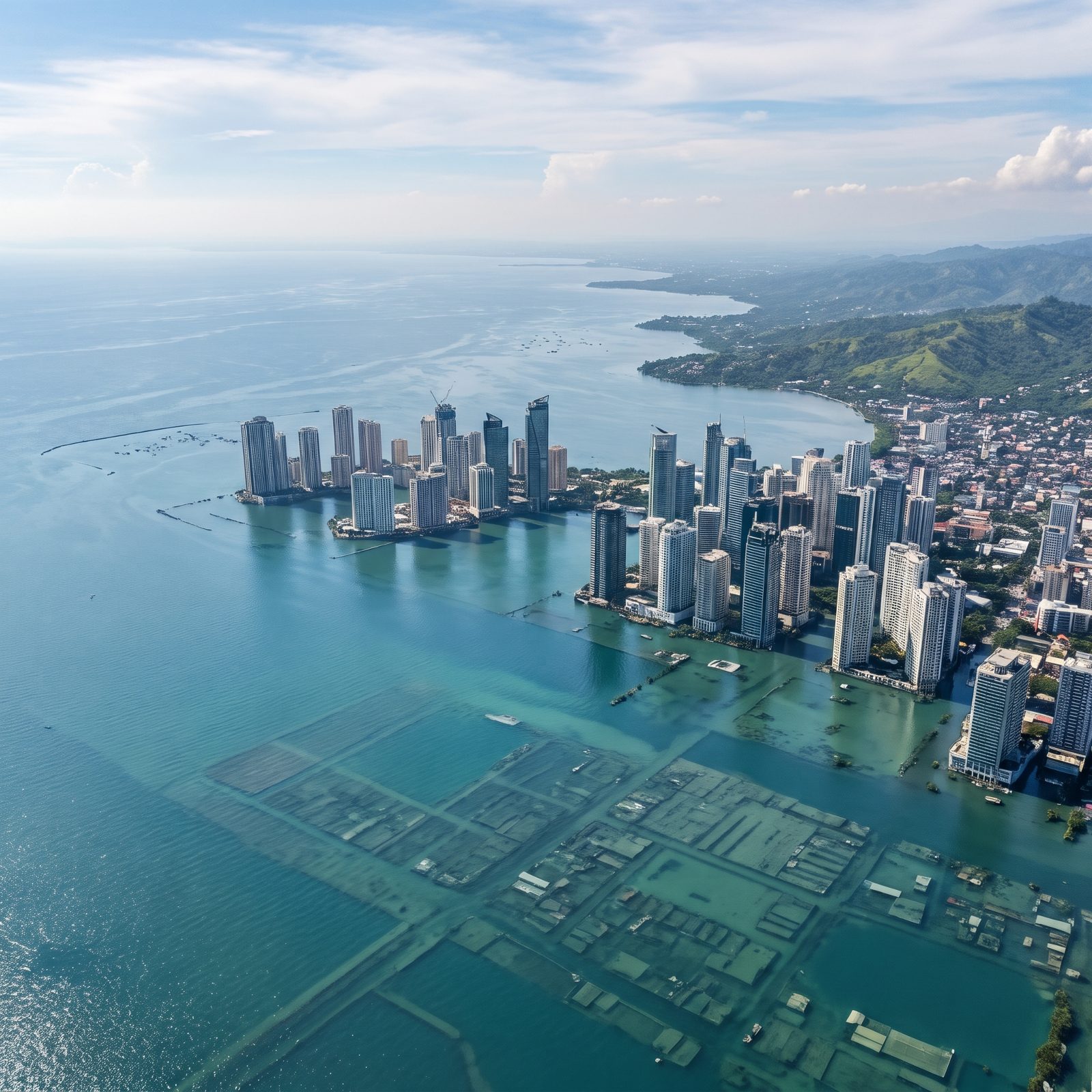
Manila sits in a trap of geography, wedged between Manila Bay on one side and the huge freshwater Laguna de Bay on the other, with low ground in between.
Raise the sea 200 feet and the two bodies of water meet in the middle. The reclaimed bayside and the coastal districts vanish, the business towers of Makati and Bonifacio stand as islands of concrete, and only the eastern foothills toward Marikina and Rizal hold a real shoreline — green against a vast calm bay where a metropolis used to spread.
11. Ho Chi Minh City, The South China Sea Floods the Mekong Plain
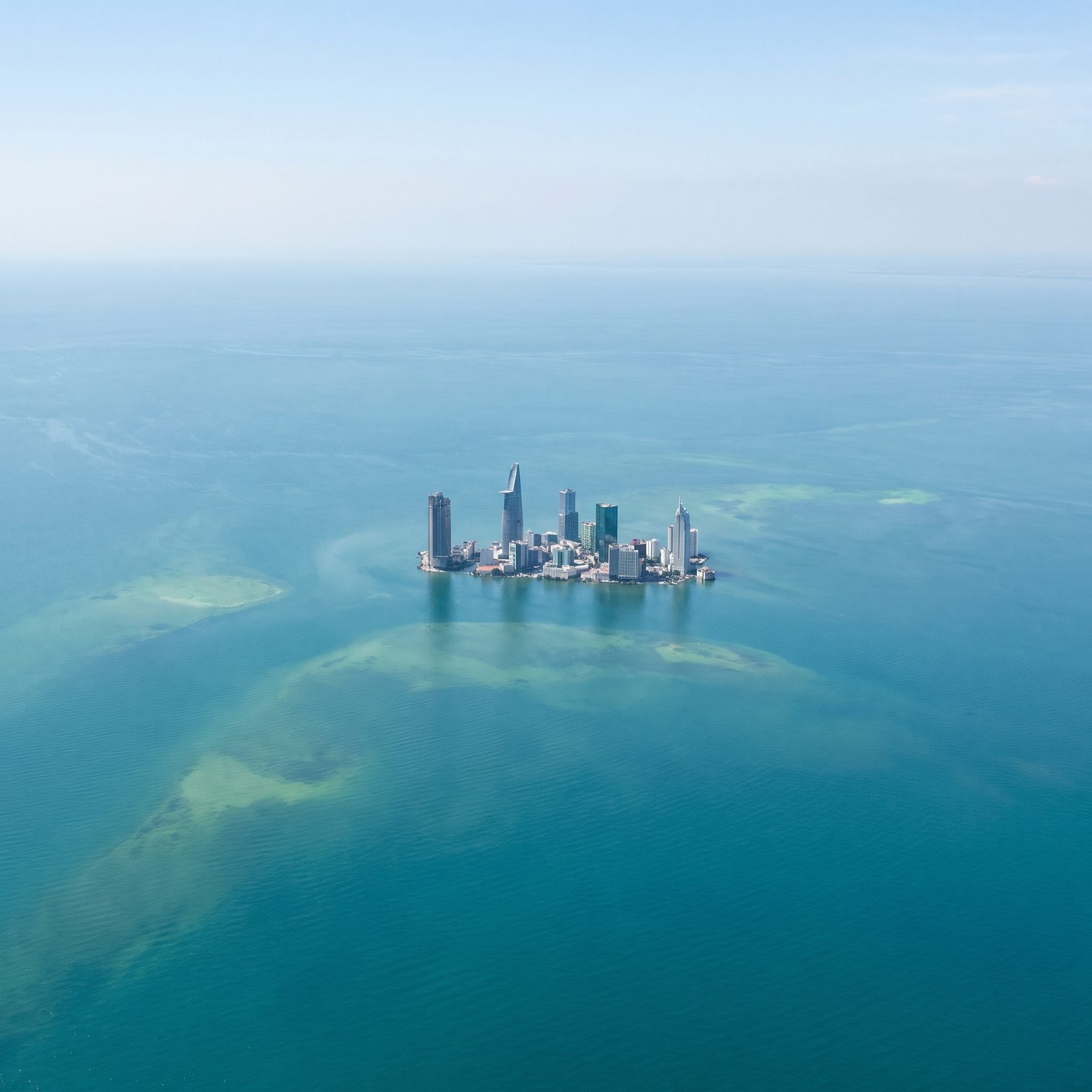
The Mekong Delta is so flat it almost dares the ocean. Much of it sits only a few feet above sea level, which makes Ho Chi Minh City one of the most exposed large cities anywhere.
At 200 feet there is barely anything left to describe, and that’s exactly the thing. The South China Sea reaches far inland across the delta and the city dissolves into open water, leaving a handful of District 1 towers as a lonely cluster in open sea, with only pale green shoals of drowned land showing beneath the surface as the water stretches toward the distant horizon.
10. Hong Kong, Victoria Harbour Widens Around the Hills
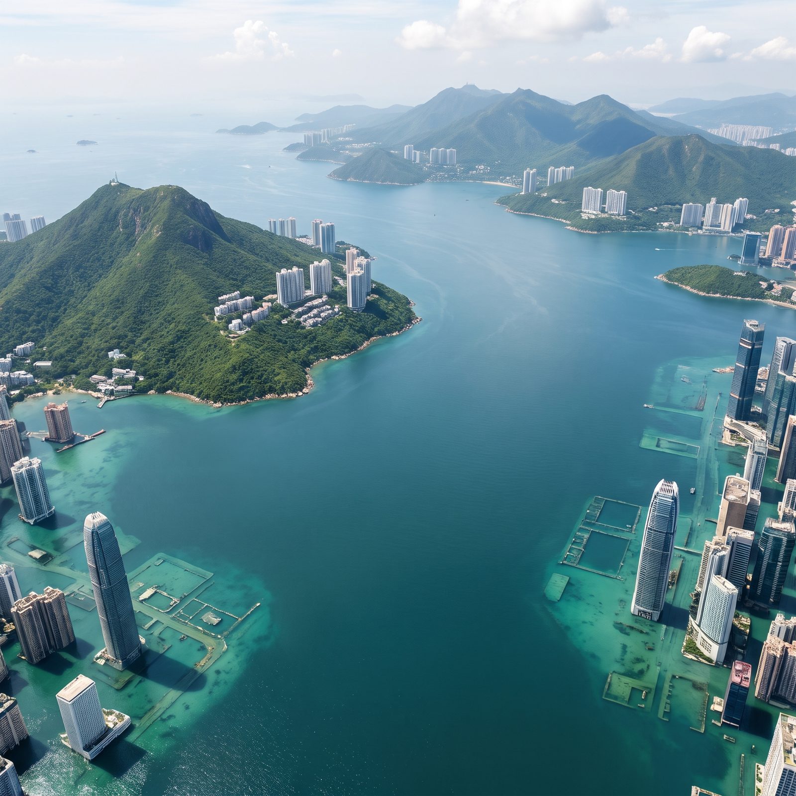
Hong Kong gets off relatively lightly, and you can thank the mountains. The city clings to steep hillsides, so the towers, villas and roads on the slopes stay dry above an ordinary-looking shoreline of beaches and piers, and the sea never reaches the Peak.
What drowns is the money. Central and Tsim Sha Tsui sit largely on land reclaimed from Victoria Harbour over more than a century, and that flat ground slips under, taking the famous waterfront skyline up to its knees. The harbor widens into a broad strait, Victoria Peak becomes a tall green island, and the towers that survive do so purely by accident of elevation.
The same hills that make Hong Kong hard to build on are the only reason any of it would still stand.
9. Shanghai, The East China Sea Swallows the Yangtze Delta
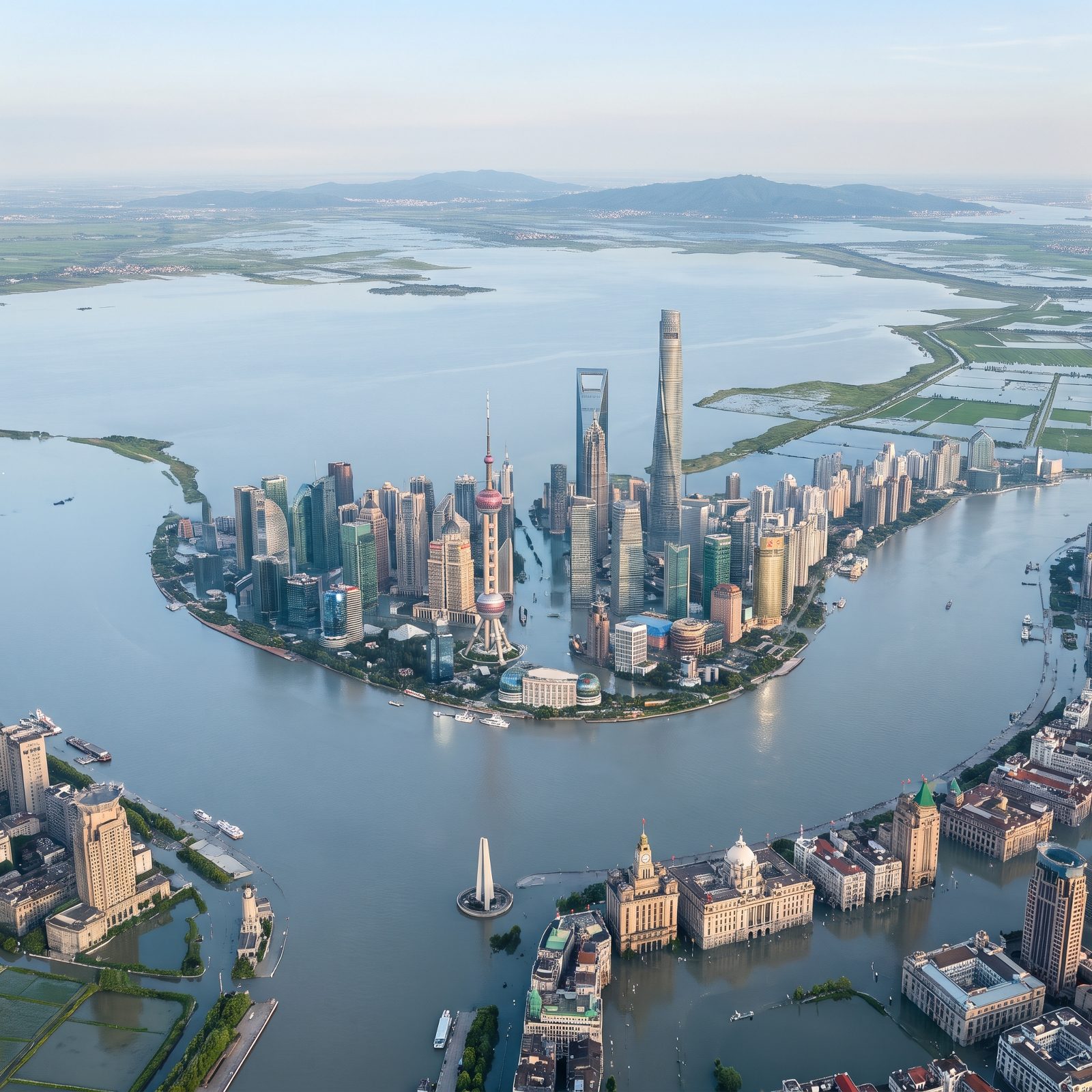
Shanghai barely clears sea level now, most of it sitting within a few meters of the tide on soft delta mud the Yangtze dropped over thousands of years. Add 200 feet of ocean and the low plain goes under.
The towers of Pudong would rise from open water, while the Bund’s old buildings sink almost out of sight. Much of the flat land behind them becomes broad shallow water reaching back toward the hills near Suzhou, with patches of farmland, paddies, levees and roads still showing above it.
8. Tokyo, The Bay Marches Deep Into the Kanto Plain
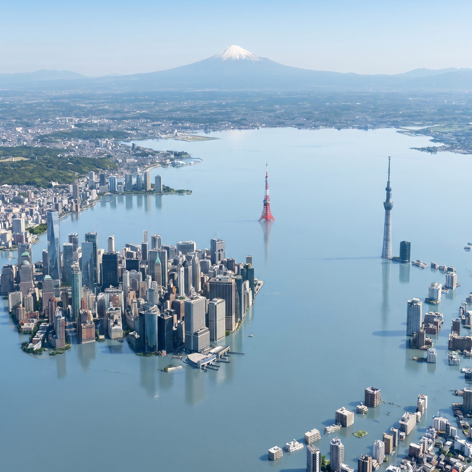
Tokyo sprawls across one of the flattest, lowest plains anywhere on Earth. The eastern wards already sit at or below the current waterline, kept dry by walls and pumps. A rise of just a few metres would leave its low-lying streets standing in water.
Raise the sea 200 feet and water would pour across the bayside wards and deep into the Kanto Plain, leaving the Skytree and Tokyo Tower rising from open water. And Fuji? It would watch over a bay that has swallowed much of the plain.
7. Osaka, Kansai’s Urban Corridor Vanishes Under the Bay
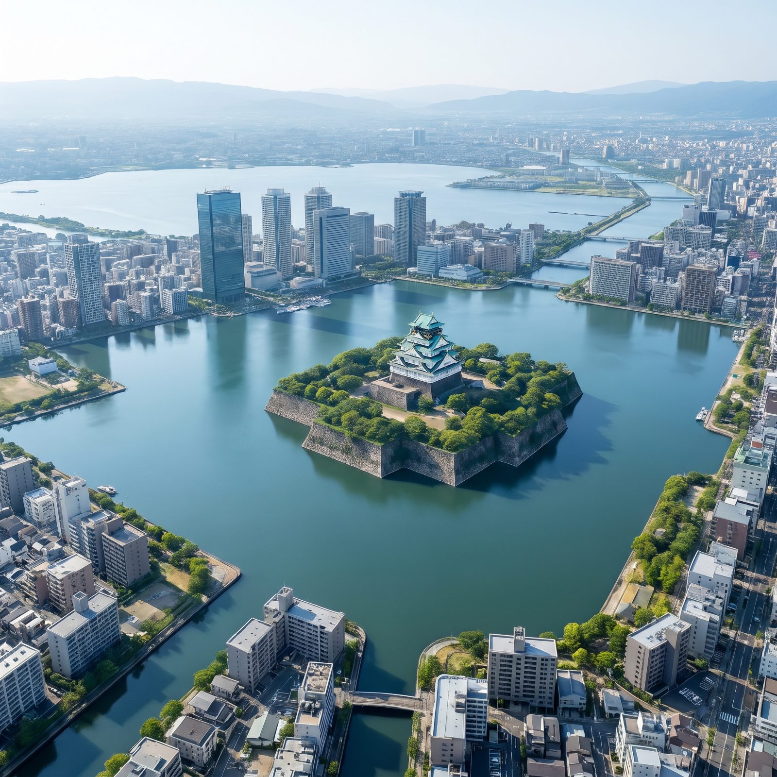
Osaka was built on reclaimed land and river delta, threaded with so many canals it earned the nickname water city. At 200 feet that history turns cruel.
The low basin holding most of Kansai’s people would flood from the bay inward, water climbing the valleys toward Kyoto. Osaka Castle, perched on its massive stone base, becomes a small fortified island. The towers survive. So, strikingly, do the low-rise apartment blocks, streets, parks and small bridges, which sit dry right at the water’s edge.
6. Sydney, The Harbour Reaches Into Low-Lying Suburbs
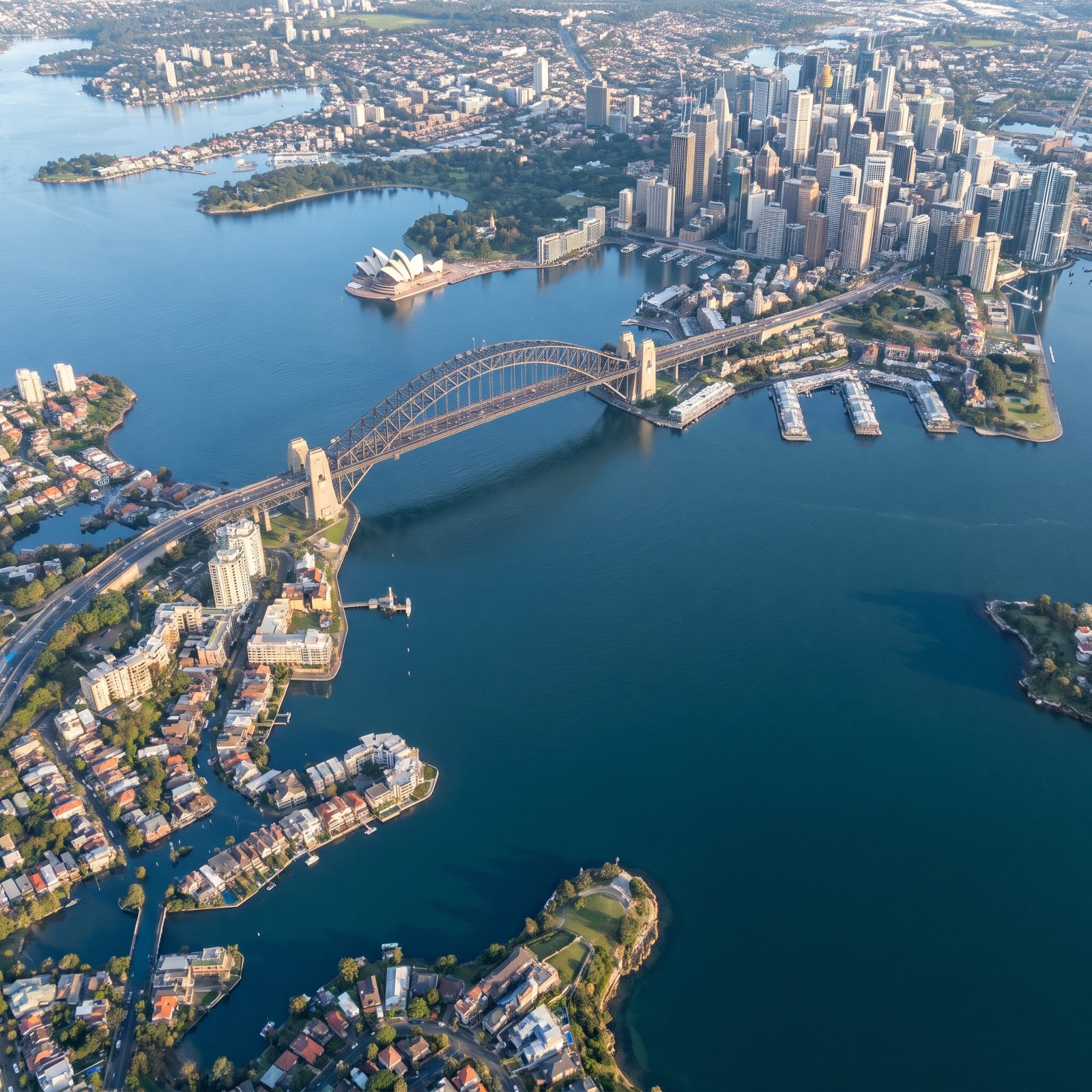
Here is the twist with Sydney. The harbour is a drowned river valley already, carved when seas were lower and flooded when they rose at the end of the last ice age. Push the water up another 200 feet and it simply keeps doing what it has always done.
The sandstone ridges that hold the CBD and much of the city sit high enough to survive. But low-lying waterfront streets are another story. Waterfront houses and gardens would sink beneath the harbour, leaving only rooftops and a few trees showing between narrow channels.
5. Melbourne, Port Phillip Bay Spreads Across the Yarra Plain
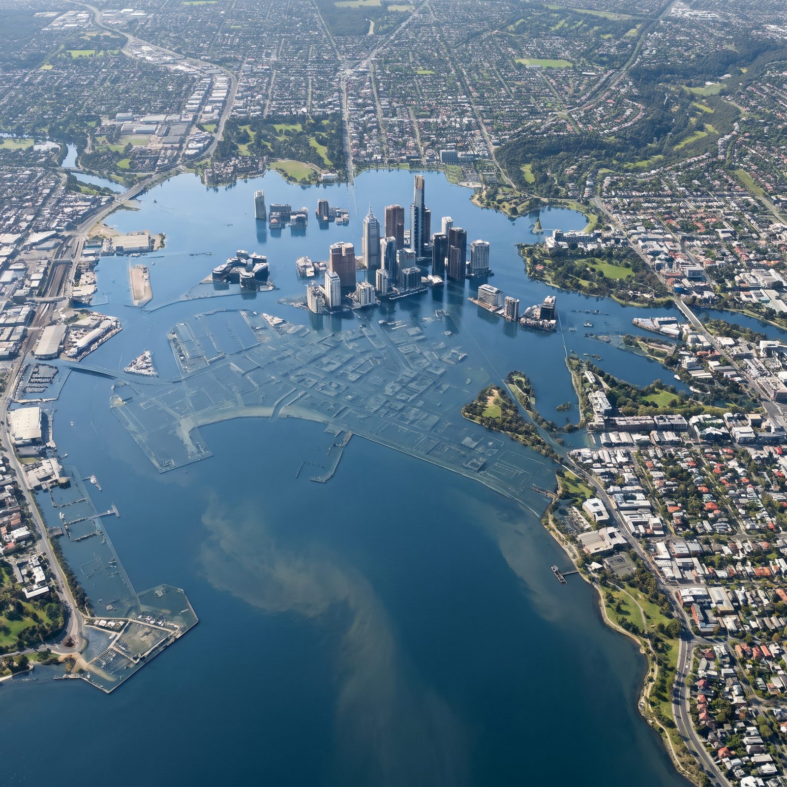
Melbourne hugs a huge shallow bay fed by a river that meanders across a flat plain. Flat and low is exactly the wrong pairing for rising water.
Port Phillip Bay would balloon inland, the Yarra becoming a wide saltwater arm rather than a river. The CBD towers hold on while the docklands and low-lying port areas around them disappear beneath the new shoreline, along with the low suburbs lining the bay’s shores.
4. Brisbane, Moreton Bay Surges Up the River Valley
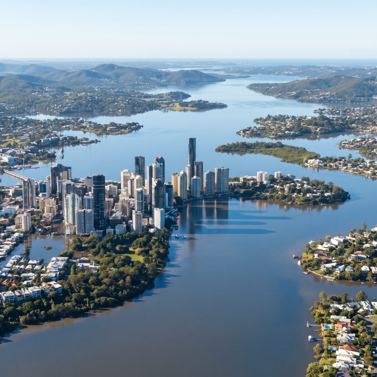
Brisbane knows water. The river floods often enough that locals mark the high lines on walls. But those floods come down the river. This kind comes up it.
Moreton Bay would push inland and the Brisbane River would widen into a long tidal sea, drowning the low bends where much of the city lives. The hills ringing the city stay dry, handing Brisbane something like an archipelago of green ridges above a new bay.
3. Auckland, Two Harbours Almost Cut the City in Half
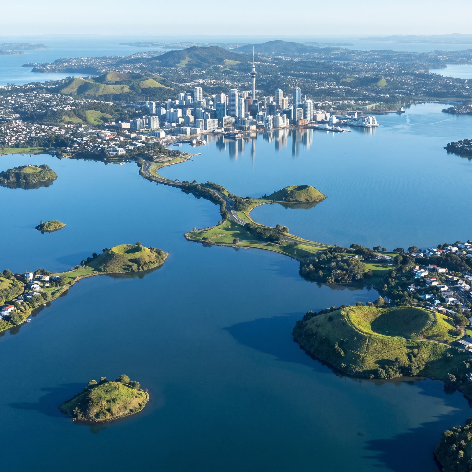
Auckland sits on a skinny neck of land with ocean on both sides, which already makes it unusual. The Waitemata Harbour laps one coast, the Manukau the other, and the city threads the narrow gap between them.
Raise the sea 200 feet and both harbours advance toward the middle until the isthmus narrows to almost nothing and the city is nearly cut in two. Auckland’s old volcanic cones, the ones that make such good lookouts now, would poke up as scattered green islands across the flood.
2. Boston, The Harbor Reclaims Its Filled-In Land
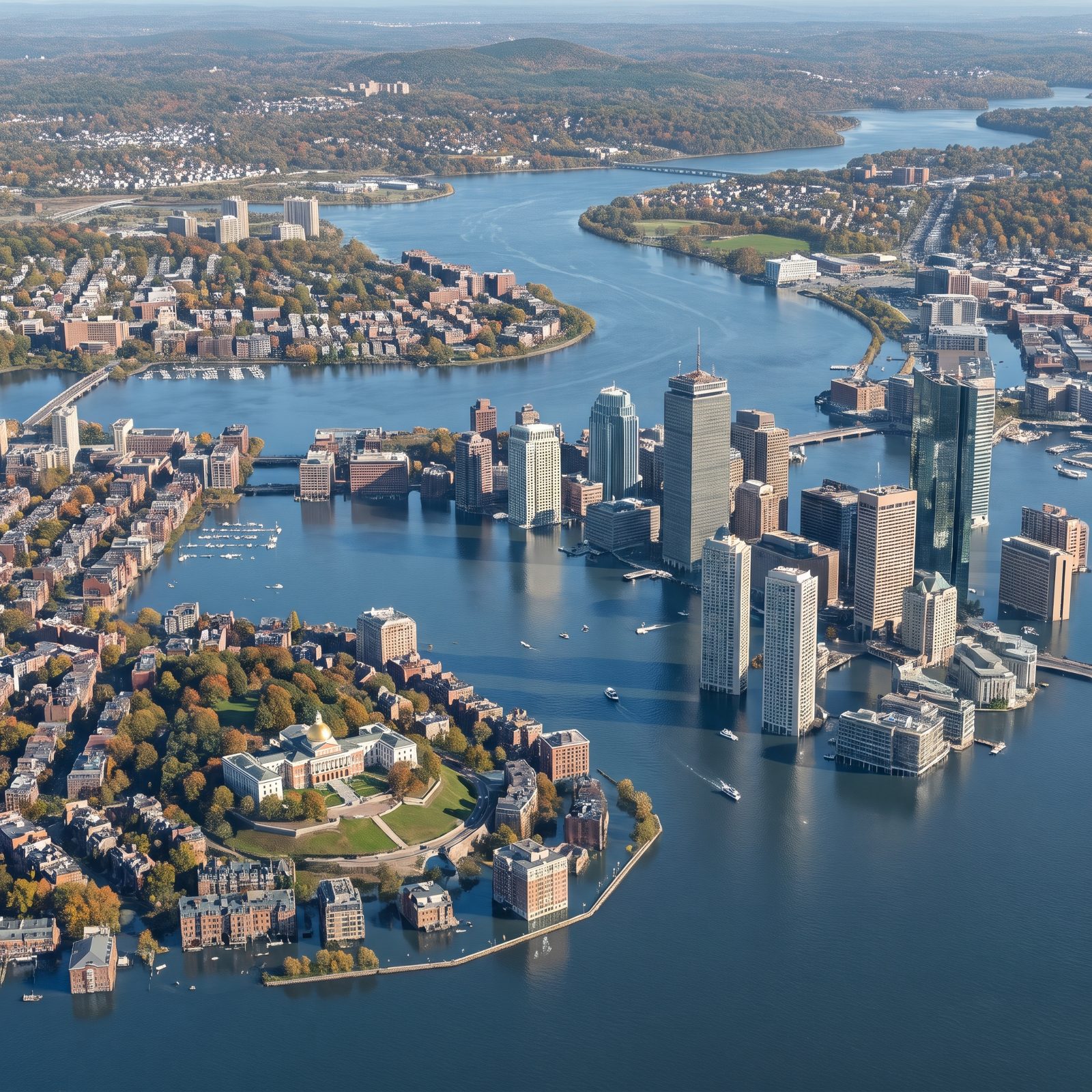
Half of downtown Boston stands on land that used to be water. Back Bay was literally a bay, filled in with gravel hauled by train in the 1800s. The sea has a long memory, and 200 feet would call that loan due.
Here, the filled districts give way: the brownstone grid, the waterfront wharves and the downtown towers all stand in floodwater, their lower floors submerged where tidal flats once lay. Only the crown of Beacon Hill, with its gold-domed State House, stays dry. Fitting, really, since the hill is one of the few parts of old Boston that was never anything but solid ground.
1. New York City, Manhattan Shrinks to a Narrow Ridge
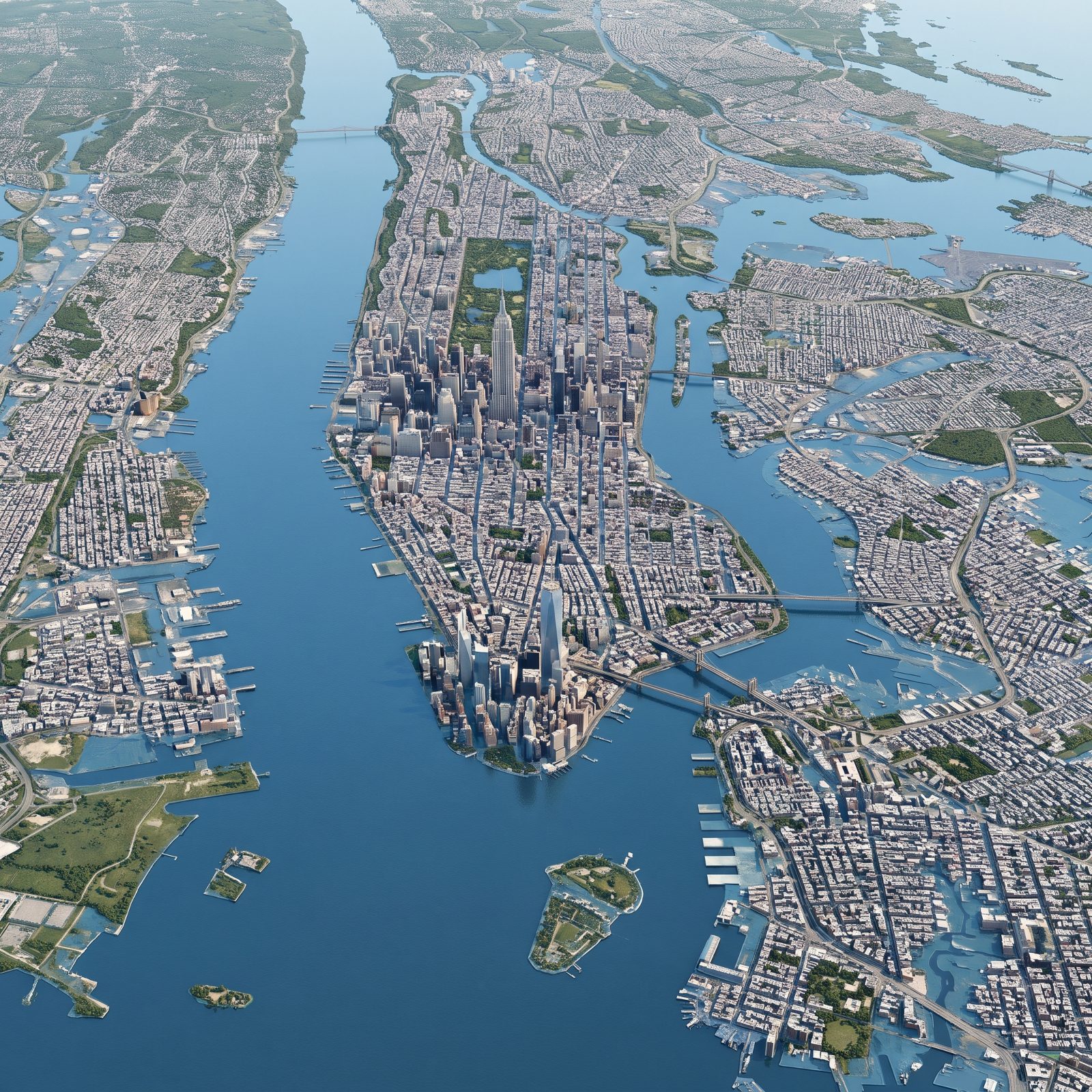
Manhattan’s skyscrapers cluster where they do for a reason. The bedrock near the surface in Midtown and the Financial District holds the weight, and that same geology hints at what a drowned Manhattan looks like.
Lower-lying ground goes under. The island narrows to a ridge, the tall towers standing on the higher bedrock while the rivers meet across the flooded low spots. The outer boroughs, flat and close to current sea level, largely vanish beneath a vastly wider harbor.